| Mount Democrat | |
|---|---|
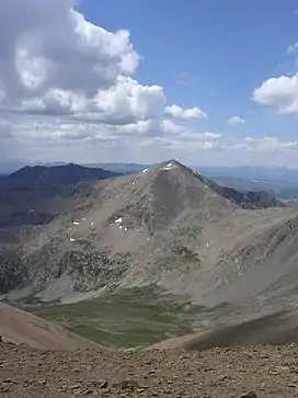
 Mount Democrat as seen from Mount Bross | |
| Highest point | |
| Elevation | 14,155 ft (4,314 m)[1][2] |
| Prominence | 768 ft (234 m)[3] |
| Parent peak | Mount Cameron |
| Isolation | 1.27 mi (2.04 km)[3] |
| Listing | Colorado Fourteener 28th |
| Coordinates | 39°20′23″N 106°08′24″W / 39.3396098°N 106.1400401°W[1] |
| Geography | |
 Mount Democrat | |
| Location | Lake and Park counties, Colorado, U.S.[4] |
| Parent range | Mosquito Range[3] |
| Topo map | USGS 7.5' topographic map Climax, Colorado[1] |
| Climbing | |
| Easiest route | East Slope: Hike, class 2[5] |
Mount Democrat is a high mountain summit in the Mosquito Range of the Rocky Mountains of North America. The 14,155-foot (4,314 m) fourteener is located 5.4 miles (8.7 km) northwest (bearing 313°) of the Town of Alma, Colorado, United States, on the Continental Divide separating San Isabel National Forest and Lake County from Pike National Forest and Park County.[1][2][3][4]
Mountain
Mount Democrat is often climbed together with Mount Lincoln and nearby Mount Bross.[6] For more information on this group of peaks, including access issues, see Mount Lincoln.
Trailhead access
The Conservation Fund, a non-profit organization that protects land and water resources, acquired 300 acres of Mount Democrat. The purchase includes the trailhead and summit, and the Conservation Fund intends to transfer the land to the United States Forest Service to ensure permanent public access.
Mount Democrat is one of Colorado's 58 fourteeners, peaks that rise above 14,000 feet in elevation. The fourteeners are a popular destination for hikers and climbers, and they can be a significant economic boon for small towns near the trailheads. However, annual visitors to Mount Democrat fell from 25,000 to 8,000 after the previous landowner closed the trailheads in 2021.
The Conservation Fund's purchase of Mount Democrat is seen as a positive development for recreation enthusiasts and the local economy. It will ensure that the public continues to have access to this iconic peak and will help support the businesses in the surrounding communities.[7]
Historical names
Before being called Mount Democrat, it was known as Republic Mountain and Mount Buckskin. [4] The Buckskin name came from a nearby town which got its name from Joseph "Buckskin Joe" Higginbottom. After the naming of Mount Lincoln in 1861, Southerners who supported the Democratic party gave the peak its current name, and it was put on official maps in 1883.[8]
See also
References
- 1 2 3 4 "MT DEMOCRAT ET". NGS Data Sheet. National Geodetic Survey, National Oceanic and Atmospheric Administration, United States Department of Commerce. Retrieved October 20, 2014.
- 1 2 The elevation of Mount Democrat includes an adjustment of +2.086 m (+6.84 ft) from NGVD 29 to NAVD 88.
- 1 2 3 4 "Mount Democrat, Colorado". Peakbagger.com. Retrieved October 20, 2014.
- 1 2 3 "Mount Democrat". Geographic Names Information System. United States Geological Survey, United States Department of the Interior. Retrieved October 29, 2014.
- ↑ "Mt. Democrat Routes". 14ers.com.
- ↑ Louis W. Dawson II (1994). Dawson's Guide to Colorado's Fourteeners, Volume 1. Blue Clover Press. ISBN 0-9628867-1-8.
- ↑ Carlton, Jim (2023-09-21). "Climbing Colorado's 'Fourteeners' Sometimes Means Trespassing. This Group Has a Solution". The Wall Street Journal. Retrieved 2023-09-22.
- ↑ Bright, William (1993). Colorado Place Names. Boulder, CO: Johnson Books. pp. 42, 87. ISBN 9781555661021.
External links
- "Mount Democrat". 14ers.com.
- Mount Democrat on Summitpost