| Thirtynine Mile Mountain | |
|---|---|
 | |
| Highest point | |
| Elevation | 11,553 ft (3,521 m)[1][2] |
| Prominence | 2,088 ft (636 m)[2] |
| Isolation | 10.61 mi (17.08 km)[2] |
| Listing | Colorado prominent summits |
| Coordinates | 38°49′56″N 105°33′18″W / 38.8322151°N 105.5549977°W[3] |
| Geography | |
 Thirtynine Mile Mountain | |
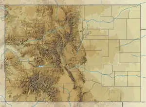
| Location | Park County, Colorado, U.S.[3] |
| Parent range | Front Range, South Park Hills[2] |
| Topo map | USGS 7.5' map Thirtynine Mile Mountain, Colorado[3] |
| Geology | |
| Volcanic arc/belt | Central Colorado volcanic field |
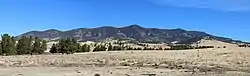
Thirtynine Mile Mountain, elevation 11,553 ft (3,521 m), is a summit in the Front Range of the Pike National Forest in central Colorado.
See also
References
- ↑ The elevation of Thirtynine Mile Mountain includes an adjustment of +1.584 m (+5.20 ft) from NGVD 29 to NAVD 88.
- 1 2 3 4 "Thirtynine Mile Mountain, Colorado". Peakbagger.com. Retrieved October 22, 2014.
- 1 2 3 "Thirtynine Mile Mountain". Geographic Names Information System. United States Geological Survey, United States Department of the Interior. Retrieved October 22, 2014.
External links
Denver (capital) | |
| Topics |
|
| Society | |
| Cities |
|
| Counties |
|
| Regions |
|
| Federal |
| ||||||||||||||||||||||||||||||||
|---|---|---|---|---|---|---|---|---|---|---|---|---|---|---|---|---|---|---|---|---|---|---|---|---|---|---|---|---|---|---|---|---|---|
| State |
| ||||||||||||||||||||||||||||||||
| Trails |
| ||||||||||||||||||||||||||||||||
This article is issued from Wikipedia. The text is licensed under Creative Commons - Attribution - Sharealike. Additional terms may apply for the media files.