Mrákov | |
|---|---|
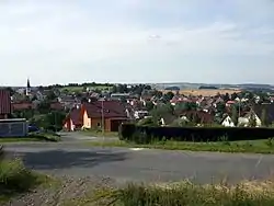 Panorama of Mrákov | |
 Flag  Coat of arms | |
 Mrákov Location in the Czech Republic | |
| Coordinates: 49°24′4″N 12°57′3″E / 49.40111°N 12.95083°E | |
| Country | |
| Region | Plzeň |
| District | Domažlice |
| First mentioned | 1325 |
| Area | |
| • Total | 20.63 km2 (7.97 sq mi) |
| Elevation | 462 m (1,516 ft) |
| Population (2023-01-01)[1] | |
| • Total | 1,149 |
| • Density | 56/km2 (140/sq mi) |
| Time zone | UTC+1 (CET) |
| • Summer (DST) | UTC+2 (CEST) |
| Postal code | 345 01 |
| Website | www |
Mrákov is a municipality and village in Domažlice District in the Plzeň Region of the Czech Republic. It has about 1,100 inhabitants.
Mrákov lies approximately 5 kilometres (3 mi) south of Domažlice, 50 km (31 mi) south-west of Plzeň, and 131 km (81 mi) south-west of Prague.
Administrative parts
Villages of Mlýneček, Nový Klíčov, Smolov and Starý Klíčov are administrative parts of Mrákov.
References
Wikimedia Commons has media related to Mrákov.
This article is issued from Wikipedia. The text is licensed under Creative Commons - Attribution - Sharealike. Additional terms may apply for the media files.