Poděvousy | |
|---|---|
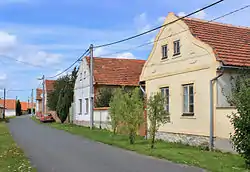 Southern part of Poděvousy | |
 Coat of arms | |
 Poděvousy Location in the Czech Republic | |
| Coordinates: 49°31′39″N 13°7′52″E / 49.52750°N 13.13111°E | |
| Country | |
| Region | Plzeň |
| District | Domažlice |
| First mentioned | 1115 |
| Area | |
| • Total | 2.73 km2 (1.05 sq mi) |
| Elevation | 447 m (1,467 ft) |
| Population (2023-01-01)[1] | |
| • Total | 236 |
| • Density | 86/km2 (220/sq mi) |
| Time zone | UTC+1 (CET) |
| • Summer (DST) | UTC+2 (CEST) |
| Postal code | 345 61 |
| Website | www |
Poděvousy is a municipality and village in Domažlice District in the Plzeň Region of the Czech Republic. It has about 200 inhabitants.
Geography
Poděvousy is located about 17 kilometres (11 mi) northeast of Domažlice and 27 km (17 mi) southwest of Plzeň. It lies on the border between the Švihov Highlands and Plasy Uplands.
History
The first written mention of Poděvousy is from 1115. Despite an unclear history, experts conclude early Feudal origin of the village. After creating a new system of political governance in 1850, it became an independent municipality.[2]
References
- ↑ "Population of Municipalities – 1 January 2023". Czech Statistical Office. 2023-05-23.
- ↑ "Obec Poděvousy" (in Czech). Obec Poděvousy. Retrieved 2022-07-07.
Wikimedia Commons has media related to Poděvousy.
This article is issued from Wikipedia. The text is licensed under Creative Commons - Attribution - Sharealike. Additional terms may apply for the media files.