Nížkovice | |
|---|---|
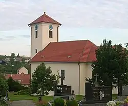 Church of Saint Cunigunde | |
 Flag  Coat of arms | |
 Nížkovice Location in the Czech Republic | |
| Coordinates: 49°6′34″N 16°54′6″E / 49.10944°N 16.90167°E | |
| Country | |
| Region | South Moravian |
| District | Vyškov |
| First mentioned | 1371 |
| Area | |
| • Total | 7.03 km2 (2.71 sq mi) |
| Elevation | 260 m (850 ft) |
| Population (2023-01-01)[1] | |
| • Total | 766 |
| • Density | 110/km2 (280/sq mi) |
| Time zone | UTC+1 (CET) |
| • Summer (DST) | UTC+2 (CEST) |
| Postal code | 683 56 |
| Website | nizkovice |
Nížkovice is a municipality and village in Vyškov District in the South Moravian Region of the Czech Republic. It has about 800 inhabitants.
Nížkovice lies approximately 19 kilometres (12 mi) south of Vyškov, 23 km (14 mi) south-east of Brno, and 210 km (130 mi) south-east of Prague.
Demographics
| Year | Pop. | ±% |
|---|---|---|
| 1869 | 654 | — |
| 1880 | 750 | +14.7% |
| 1890 | 825 | +10.0% |
| 1900 | 862 | +4.5% |
| 1910 | 952 | +10.4% |
| 1921 | 922 | −3.2% |
| 1930 | 971 | +5.3% |
| 1950 | 873 | −10.1% |
| 1961 | 926 | +6.1% |
| 1970 | 934 | +0.9% |
| 1980 | 820 | −12.2% |
| 1991 | 641 | −21.8% |
| 2001 | 667 | +4.1% |
| 2011 | 659 | −1.2% |
| 2021 | 750 | +13.8% |
| Source: Censuses[2][3] | ||
References
- ↑ "Population of Municipalities – 1 January 2023". Czech Statistical Office. 2023-05-23.
- ↑ "Historický lexikon obcí České republiky 1869–2011 – Okres Vyškov" (in Czech). Czech Statistical Office. 2015-12-21.
- ↑ "Population Census 2021: Population by sex". Public Database. Czech Statistical Office. 2021-03-27.
Wikimedia Commons has media related to Nížkovice.
This article is issued from Wikipedia. The text is licensed under Creative Commons - Attribution - Sharealike. Additional terms may apply for the media files.