Podomí | |
|---|---|
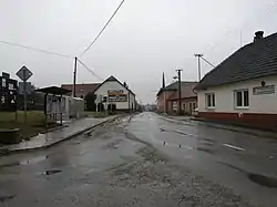 Main street | |
 Flag  Coat of arms | |
 Podomí Location in the Czech Republic | |
| Coordinates: 49°20′41″N 16°50′0″E / 49.34472°N 16.83333°E | |
| Country | |
| Region | South Moravian |
| District | Vyškov |
| First mentioned | 1349 |
| Area | |
| • Total | 5.46 km2 (2.11 sq mi) |
| Elevation | 552 m (1,811 ft) |
| Population (2023-01-01)[1] | |
| • Total | 450 |
| • Density | 82/km2 (210/sq mi) |
| Time zone | UTC+1 (CET) |
| • Summer (DST) | UTC+2 (CEST) |
| Postal code | 683 04 |
| Website | www |
Podomí is a municipality and village in Vyškov District in the South Moravian Region of the Czech Republic. It has about 500 inhabitants.
Podomí lies approximately 13 kilometres (8 mi) north-west of Vyškov, 24 km (15 mi) north-east of Brno, and 194 km (121 mi) south-east of Prague.
History
The first written mention of Podomí is from 1349, when it was part of the Holštejn estate.[2]
Demographics
| Year | Pop. | ±% |
|---|---|---|
| 1869 | 501 | — |
| 1880 | 540 | +7.8% |
| 1890 | 593 | +9.8% |
| 1900 | 612 | +3.2% |
| 1910 | 673 | +10.0% |
| 1921 | 602 | −10.5% |
| 1930 | 548 | −9.0% |
| 1950 | 493 | −10.0% |
| 1961 | 495 | +0.4% |
| 1970 | 465 | −6.1% |
| 1980 | 482 | +3.7% |
| 1991 | 435 | −9.8% |
| 2001 | 422 | −3.0% |
| 2011 | 413 | −2.1% |
| 2021 | 421 | +1.9% |
| Source: Censuses[3][4] | ||
Notable people
- Ervín Černý (1913–2001), physician and university professor
References
- ↑ "Population of Municipalities – 1 January 2023". Czech Statistical Office. 2023-05-23.
- ↑ "Historie" (in Czech). Obec Podomí. Retrieved 2022-11-19.
- ↑ "Historický lexikon obcí České republiky 1869–2011 – Okres Vyškov" (in Czech). Czech Statistical Office. 2015-12-21.
- ↑ "Population Census 2021: Population by sex". Public Database. Czech Statistical Office. 2021-03-27.
Wikimedia Commons has media related to Podomí.
This article is issued from Wikipedia. The text is licensed under Creative Commons - Attribution - Sharealike. Additional terms may apply for the media files.