Norris, South Dakota | |
|---|---|
 Norris, South Dakota  Norris, South Dakota | |
| Coordinates: 43°28′20″N 101°11′34″W / 43.47222°N 101.19278°W | |
| Country | United States |
| State | South Dakota |
| County | Mellette |
| Area | |
| • Total | 0.83 sq mi (2.15 km2) |
| • Land | 0.83 sq mi (2.15 km2) |
| • Water | 0.00 sq mi (0.00 km2) |
| Elevation | 2,494 ft (760 m) |
| Population | |
| • Total | 150 |
| • Density | 180.72/sq mi (69.75/km2) |
| Time zone | UTC-6 (Central (CST)) |
| • Summer (DST) | UTC-5 (CDT) |
| ZIP code | 57560 |
| Area code | 605 |
| FIPS code | 46-45460[4] |
| GNIS feature ID | 2584562[2] |
Norris is an unincorporated community in Mellette County, South Dakota, United States, which is not specifically tracked by the Census Bureau, but rather is only included in the census-designated place of the same name. The population of the CDP was 150 at the 2020 census.[5] Norris has the post office which serves the 57560 ZIP code area, which also includes the town of Corn Creek.
Norris was laid out in 1910, and named after a nephew of the town's merchant.[6]
Demographics
| Census | Pop. | Note | %± |
|---|---|---|---|
| 2020 | 150 | — | |
| U.S. Decennial Census[7] | |||
References
- ↑ "ArcGIS REST Services Directory". United States Census Bureau. Retrieved October 15, 2022.
- 1 2 U.S. Geological Survey Geographic Names Information System: Norris, South Dakota
- ↑ "Census Population API". United States Census Bureau. Retrieved October 15, 2022.
- ↑ "U.S. Census website". United States Census Bureau. Retrieved January 31, 2008.
- ↑ "U.S. Census Bureau: Norris CDP, South Dakota". www.census.gov. United States Census Bureau. Retrieved February 21, 2022.
- ↑ Federal Writers' Project (1940). South Dakota place-names, v.1-3. University of South Dakota. p. 52.
- ↑ "Census of Population and Housing". Census.gov. Retrieved June 4, 2016.
Municipalities and communities of Mellette County, South Dakota, United States | ||
|---|---|---|
| City | 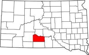 | |
| Town | ||
| CDPs | ||
| Other communities | ||
| Indian reservation | ||
| Ghost town | ||
| Footnotes | ‡This populated place also has portions in an adjacent county or counties | |
This article is issued from Wikipedia. The text is licensed under Creative Commons - Attribution - Sharealike. Additional terms may apply for the media files.