Route 360 | ||||
|---|---|---|---|---|
| Route information | ||||
| Maintained by Nova Scotia Department of Transportation and Infrastructure Renewal | ||||
| Length | 22 km[1] (14 mi) | |||
| Major junctions | ||||
| South end | Aylesford Road in Morristown | |||
| North end | Long Point Road in Harbourville | |||
| Location | ||||
| Country | Canada | |||
| Province | Nova Scotia | |||
| Highway system | ||||
| ||||
Route 360 is a collector road in the Canadian province of Nova Scotia.
It is located in Kings County and connects Berwick at Trunk 1 with Harbourville.
It climbs the steep southern slope of the North Mountain in a sharp hairpin turn known locally as "The Oxbow".
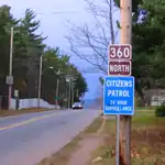
View near junction of Nova Scotia Route 360 and Trunk 1 at Berwick, Nova Scotia.
Communities
See also
References
This article is issued from Wikipedia. The text is licensed under Creative Commons - Attribution - Sharealike. Additional terms may apply for the media files.