 | |
|---|---|
 | |
| Route information | |
| Length | 57.3 km (35.6 mi) |
| Existed | 1975–present |
| Major junctions | |
| From | Naha Interchange in Naha, Okinawa Prefectural Route 82 |
| To | Kyoda Interchange in Nago, Okinawa |
| Location | |
| Country | Japan |
| Major cities | Naha, Urasoe, Ginowan, Okinawa, Uruma |
| Highway system | |
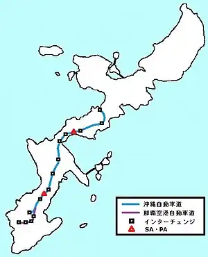
The Okinawa Expressway (沖縄自動車道, Okinawa Jidōsha-dō) is an expressway on Okinawa Island in Okinawa Prefecture, Japan. The expressway has a length of 57.3 kilometers (35.6 mi). The West Nippon Expressway Company is the owner and operator of this expressway. It is signed E58 under the "2016 Proposal for Realization of Expressway Numbering".[1]
Route description
Tolls
The toll from end to end is 1020 yen for normal-sized cars and 840 yen for kei cars.[2] For comparison, the Tōmei and Tōhoku Expressways radiating from Tokyo have tolls of about 1650 yen for similar distances.[3]
Utilization
In 2002, an average of 23,910 vehicles per day used the expressway. This was a 5.6% increase from the previous year. This is the only expressway in Japan having more than 20% kei car traffic; the national average is 7.3%.
Junction list
The entire expressway is in Okinawa Prefecture.
| Location | km[4] | mi | Exit | Name | Destinations | Notes | |
|---|---|---|---|---|---|---|---|
| Naha | 0 | 0.0 | 1 | Naha | Southern terminus; partially signaled intersection | ||
| Nishihara | 2.4 | 1.5 | 1-1 | Nishihara | Southbound exit, northbound entrance | ||
| Urasoe | 5.6 | 3.5 | 2 | Nishihara | |||
| Nakagusuku | 10.2 | 6.3 | PA | Nakagusuku Parking Area | |||
| Kitanakagusuku | 12.0 | 7.5 | 3 | Kitanakagusuku | Okinawa Prefecture Route 29 – Ginowan, Kitanakagusuku | ||
| 13.4 | 8.3 | 3-1 | Kishaba | Okinawa Prefecture Route 81 | Southbound entrance only Access only for vehicles equipped with ETC | ||
| Okinawa | 17.8 | 11.1 | 4 | Okinawa-minami | Okinawa Prefecture Route 85 – Okinawa, Kadena, Chatan | ||
| 22.9 | 14.2 | 5 | Okinawa-kita | Okinawa Prefecture Route 36 east – Uruma | |||
| Uruma | 31.4 | 19.5 | 6 | Ishikawa | |||
| Kin | 34.1 | 21.2 | 7 | Yaka | Okinawa Prefecture Route 88 – Ishikawa, Nago | Southbound entrance, northbound exit | |
| 36.7 | 22.8 | SA | Igei Service Area | ||||
| 39.9 | 24.8 | 8 | Kin | ||||
| Ginoza | 48.1 | 29.9 | 9 | Ginoza | |||
| Nago | 57.3 | 35.6 | 10 | Kyoda | Northern terminus | ||
| 1.000 mi = 1.609 km; 1.000 km = 0.621 mi | |||||||
References
- ↑ "Japan's Expressway Numbering System". www.mlit.go.jp.
- ↑ "Okinawa Expressway and ETC". Okinawa Hai. 23 May 2016. Retrieved 4 September 2020.
- ↑ "Tōhoku Expressway fare Urawa to Sano-Fujioka". East Nippon Expressway Company. 4 September 2020. Retrieved 4 September 2020.
- ↑ Google (3 September 2020). "Okinawa Expressway" (Map). Google Maps. Google. Retrieved 3 September 2020.