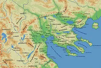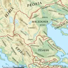
Orestis (Greek: Ορέστις) was a region of Upper Macedonia, corresponding roughly to the modern Kastoria regional unit located in West Macedonia, Greece. Its inhabitants were the Orestae, an ancient Greek tribe that was part of the Molossian tribal state or koinon.[1][2][3][4][5]
Etymology
The term Orestis is derived from the Greek word orestias meaning "of the mountains" or "mountainous".[6]
Geography
It is generally agreed that the region of Orestis encompassed the area around Lake Kastoria and the upper Haliacmon basin.[7] [8] The region was bounded geographically by the mountains Voio, Vitsi and Grammos and it extended to Prespa Lakes basin, in particular around Small Prespa Lake, where the ancient settlement of Lyke was located.[9][10][11] Orestis bordered to the southwest Molossians and other Epirotic peoples, to the northwest Dassaretia, to the west Parauaia, to the northeast Eordaea and to the southeast Elimiotis.[10]

There is an overall agreement only for the eastern borders of the region, while about the rest of the Orestis' border areas there is some disagreement in scholarship.[12] For Hammond, Orestis to the southeast ended after the point where the Pramoritsa flows into the Haliacmon (near Trapezitsa), while for Papazoglou it extended southwest of this point up to Palaiokastro and Siatista.[10] For Papazoglou, the border with Dassaretia was defined by the Cangonj Pass while the Bilisht-Poloskë valley to the east of the pass was part of Orestia. Papazoglou adds that the mountains of Morava (between Korcë plain and Poloskë basin) and Grammos probably formed the border with Dassaretia and Parauaia. Karamitrou-Mentesidi is in favour of an excessive western expansion on lake Maliq and the region of today's Korcë.[13] In general modern scholarship agrees on the western border of Orestis being found slightly west from the modern Greek-Albanian border.[13] The northern boundary of Orestis corresponded to the southern shore of Small Prespa Lake.[10][14]
Some important cities in the Orestis region based on ancient sources were Argos Orestikon, Celetrum (Kelethron), Diokliteionopolis, while epigraphic evidence cofirms the existence of Battyna and Lykke.[13]
Orestis was traditionally a district of Upper Macedonia,[7] forming its heartland in the Archaic and early Classical periods.[15] It bordered with Lynkestis to the north, Eordaia to the north-east, Elimiotis to the south-east, Tymphaea to the south, and Illyrians to the west.[16] Orestis formed the western border of Upper Macedonia, and Illyrians beyond this district constituted a persistent menace to the stability of the Kingdom of Macedon.[7]
Orestis was among the regions of Upper Macedonia where the inhabitants were tribal peoples, who gave their name to the territory which was under their control, or alternatively who took their name from that territory. The tribal people that inhabited Orestis were the Orestae.[7]
Orestis, like the rest of Upper Macedonia, was characterized by cold winters with rainfalls that were very heavy, and hot summers. In this region life was hard and mainly a matter of survival. According to the season of the year, the mostly nomadic pastoralist people of the area moved their flocks of cattle, goats and sheep to the various pasture lands.[17] The region of Orestis was rich in summer pastures.[18]
History
Αn abundance of Mycenaean findings (both imported and locally made) from the late Bronze Age have been unearthed from various tombs in the region of Orestis. These include pottery, weapons, pins, brooches, as well as Linear B inscriptions.[19]
Appian and Hesiod mention about the origins of the Argead dynasty of the Macedonian royal house that they were descedants of Argeas from Orestis, the later being son of the eponymous Macedon. The Argeads then wandered from Orestis to Lower Macedonia, where they founded the ancient Greek kingdom of Macedon.[20][21] Also according to Appian, Argos Orestikon (in modern Orestida), rather than the Peloponnesian Argos, was the homeland of the Argead dynasty.[22]
Both 6th century geographer Hecataeus and later Strabo identified the Orestea as Molossian population of the Epirote group.[1][11] A 6th century BC silver finger ring bearing the common Orestian name "Antiochus", was found in the Dodona sanctuary.[23] During the Peloponnesian War, a thousand Orestians led by King Antiochus, accompanied the Parauaeans of Epirus.[24]
Like most of Upper Macedonia, Orestis only became part of Macedon after the early 4th century BC; before that, it had close relations with Epirus. This change possible happened during the reign of Philip II of Macedon.[25]
Natives of the region were: Pausanias of Orestis, the lover and assassin of Philip II, and three of Alexander's prominent diadochi: Perdiccas (son of Orontes), Seleucus I Nicator (son of Antiochus), his uncle Ptolemy, and the sons of a noble from Orestis named Alexander; Craterus and Amphoterus.
The region became independent again in 196 BC, when the Romans, after defeating Philip V (r. 221–179 BC), declared the Orestae free because they had supported the Roman cause in the recent war against Macedon.[26][27]
Religion
An inscription from the upper Devoll valley, lists Artemis with the epithet Syvonnike, while depictions of the goddess are found in various parts of the Orestis region.[28]
See also
References
Citations
- 1 2 Hammond 1982, p. 266: "On crossing the Balkan chain, we find that Hecataeus called the Orestae 'a Molossian tribe' (F 107), and Strabo (434; cf. 326) probably derived from Hecataeus his belief that the Elimeotae, Lyncestae, and Pelagones, as well as the Orestae, were Epirotic or rather Molossian tribes before their incorporation by the Macedones into the Macedonian kingdom."
- ↑ Hornblower, Spawforth & Eidinow 2012, p. 966: "Molossi, common name of tribes forming a tribal state (koinon) in Epirus, which originated in northern Pindus including the Orestae, FGrH 1 F 107) and expanded southwards, reaching the Ambraciote Gulf (see AMBRACIA) c.370 BC."
- ↑ Hammond 1967, p. 703: "The Orestae were Molossian (as we know from a fourth-century inscription)."
- ↑ Hammond 2001, p. 158: "Pelagones in the region of Prilep, the Lyncestae in the region of Florina, the Orestae in the region of Kastoria, and the Elimeotae in the region of Kozani. These tribes were all Epirotic tribes and they talked the Greek language but with a different dialect, the Northwest Greek dialect, as we know now from the local questions which were put to the god of Dodona."
- ↑ Borza 1992, p. 74: "The western Greek people (with affinities to the Epirotic tribes) in Orestis, Lyncus, and parts of Pelagonia."
- ↑ Liddell & Scott 1940: ὀρεστιάς.
- 1 2 3 4 King 2017, p. 5.
- ↑ Hatzopoulos 2011, p. 45.
- ↑ Nigdelis & Souris 1997, p. 55
- 1 2 3 4 Papazoglou 1988, p. 233.
- 1 2 Mallios 2011, p. 146.
- ↑ Hatzinikolaou 2011, pp. 9.
- 1 2 3 Hatzinikolaou 2011, pp. 10.
- ↑ Hatzinikolaou 2011, pp. 9–10, 19.
- ↑ King 2017, p. 6.
- ↑ King 2017, pp. 5–6.
- ↑ Worthington 2008, p. 6
- ↑ Heckel, Heinrichs & Müller 2020, p. 372.
- ↑ Hatzopoulos 2011, p. 53
- ↑ Hatzopoulos 2017, pp. 314–324
- ↑ Roisman & Worthington 2010, p. 379
- ↑ Appian. Syrian Wars, 11.10.63.
- ↑ PAAH (1929) 122.
- ↑ Thucydides. History of the Peloponnesian War, 2.80.
- ↑ Dominguez 2022, p. 475
- ↑ Samsaris 1989, pp. 64–65
- ↑ Titus Livy. Ab Urbe Condita, 33.34.5: "To the Orestae — that is a tribe of the Macedonians — their own laws were restored, because they had been the first to revolt against the king."
- ↑ Hatzinikolaou 2007, pp. 139–141
Sources
- Borza, Eugene N. (1992). In the Shadow of Olympus: The Emergence of Macedon (Revised ed.). Princeton, NJ: Princeton University Press. ISBN 0-691-00880-9.
- Dominguez, Adolfo (2022). "Agrarian and Power Landscapes in Epeiros during the Late Classical and Hellenistic Periods". Gerión. Revista de Historia Antigua. 40 (2): 463–494. doi:10.5209/geri.82776. ISSN 1988-3080. S2CID 253825174. Retrieved 30 May 2023.
- Hammond, Nicholas Geoffrey Lemprière (2001). Collected Studies: Further Studies on Various Topics. Vol. V. Amsterdam: Hakkert.
- Hammond, Nicholas Geoffrey Lemprière (1982). "CHAPTER 40 ILLYRIS, EPIRUS AND MACEDONIA". In Boardman, John; Hammond, Nicholas Geoffrey Lemprière (eds.). The Cambridge Ancient History: The Expansion of the Greek World, Eighth to Sixth Centuries B.C. Vol. III, Part 3 (2nd ed.). Cambridge: Cambridge University Press. pp. 261–285. ISBN 0-521-23447-6.
- Hammond, Nicholas Geoffrey Lemprière (1967). Epirus: The Geography, the Ancient Remains, the History and the Topography of Epirus and Adjacent Areas. Oxford: The Clarendon Press.
- Hatzinikolaou, Kalliopi (2007). "Cults of Upper Macedonia". Didaktorika.gr. Retrieved 28 May 2023.
- Hatzinikolaou, Kalliopi (2011). "On the Historical Geography of Upper Macedonia". Makedonika (in Greek). 38: 1. doi:10.12681/makedonika.58. ISSN 2241-2018. Retrieved 28 May 2023.
- Hatzopoulos, M. B. (2011). "Macedonia and Macedonians". In Lane Fox, Robin J. (ed.). Brill's Companion to Ancient Macedon: Studies in the Archaeology and History of Macedon, 650 BC – 300 AD. Leiden: Brill. pp. 43–50. ISBN 978-90-04-20650-2.
- Hatzopoulos, Miltiades B. (2017). "Recent Research in the Ancient Macedonian Dialect: Consolidation and New Perspectives". Studies in Ancient Greek Dialects. Berlin: De Gruyter. pp. 299–328. doi:10.1515/9783110532135-016. ISBN 978-3-11-053213-5.
- Heckel, Waldemar; Heinrichs, Johannes; Müller, Sabine, eds. (2020). Lexicon of Argead Makedonia. Frank & Timme GmbH. ISBN 978-3732904051.
- Hornblower, Simon; Spawforth, Antony; Eidinow, Esther (2012) [1949]. The Oxford Classical Dictionary (4th ed.). Oxford: Oxford University Press. ISBN 978-0-19-954556-8.
- Karamitrou-Mentesidi, Georgia; Moschakis, Kostas (2014). "Medicine in Aeani and Upper Macedonia in Antiquity". Medicine and Healing in the Ancient Mediterranean. Oxbow Books. ISBN 9781782972358. Retrieved 28 May 2023.
- King, Carol J. (2017). Ancient Macedonia. Routledge. ISBN 978-1-351-71031-2.
- Liddell, Henry George; Scott, Robert (1940). A Greek-English Lexicon. Oxford: Clarendon Press.
- Mallios, Giorgos (2011). Myth and History: The Case of Ancient Macedonia. University of Thessaloniki. p. 146. Retrieved 27 May 2023.
- Nigdelis, P. M.; Souris, G. A. (1997). "Πόλεις and Πολιτεῖαι in upper Macedonia under the Principate: A new inscription from Lyke in Orestis". Tekmeria. 3: 55–63. doi:10.12681/tekmeria.120. ISSN 1791-7573. Retrieved 28 May 2023.
- Historical Geography of the Roman Province of Macedonia (PDF) (in Greek). Thessaloniki: Society of Macedonian Studies. 1989. ISBN 9607265017.
- Papazoglou, Fanoula (1988). Les villes de Macédoine à l'époque romaine (in French). Ecole française d'Athènes. ISBN 978-2-86958-014-5.
- Worthington, Ian (2008). Philip II of Macedonia. Yale University Press. ISBN 9780300120790.
- Roisman, Joseph; Worthington, Ian (2010). A Companion to Ancient Macedonia. John Wiley & Sons. ISBN 978-1-4051-7936-2.