Orvillers-Sorel | |
|---|---|
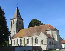 The church in Orvillers-Sorel | |
.svg.png.webp) Coat of arms | |
Location of Orvillers-Sorel | |
 Orvillers-Sorel  Orvillers-Sorel | |
| Coordinates: 49°34′44″N 2°42′30″E / 49.5789°N 2.7083°E | |
| Country | France |
| Region | Hauts-de-France |
| Department | Oise |
| Arrondissement | Compiègne |
| Canton | Estrées-Saint-Denis |
| Intercommunality | Pays des Sources |
| Government | |
| • Mayor (2020–2026) | Francis Cormier[1] |
| Area 1 | 8.51 km2 (3.29 sq mi) |
| Population | 521 |
| • Density | 61/km2 (160/sq mi) |
| Time zone | UTC+01:00 (CET) |
| • Summer (DST) | UTC+02:00 (CEST) |
| INSEE/Postal code | 60483 /60490 |
| Elevation | 69–112 m (226–367 ft) (avg. 105 m or 344 ft) |
| 1 French Land Register data, which excludes lakes, ponds, glaciers > 1 km2 (0.386 sq mi or 247 acres) and river estuaries. | |
Orvillers-Sorel is a commune in the Oise department in northern France.
See also
References
- ↑ "Répertoire national des élus: les maires". data.gouv.fr, Plateforme ouverte des données publiques françaises (in French). 9 August 2021.
- ↑ "Populations légales 2021". The National Institute of Statistics and Economic Studies. 28 December 2023.
Wikimedia Commons has media related to Orvillers-Sorel.
This article is issued from Wikipedia. The text is licensed under Creative Commons - Attribution - Sharealike. Additional terms may apply for the media files.