Penne-d'Agenais | |
|---|---|
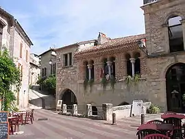 A view within Penne-d'Agenais | |
.svg.png.webp) Coat of arms | |
Location of Penne-d'Agenais | |
 Penne-d'Agenais  Penne-d'Agenais | |
| Coordinates: 44°23′23″N 0°49′11″E / 44.3897°N 0.8197°E | |
| Country | France |
| Region | Nouvelle-Aquitaine |
| Department | Lot-et-Garonne |
| Arrondissement | Villeneuve-sur-Lot |
| Canton | Le Pays de Serres |
| Intercommunality | Fumel Vallée du Lot |
| Government | |
| • Mayor (2020–2026) | Arnaud Devilliers[1] |
| Area 1 | 46.71 km2 (18.03 sq mi) |
| Population | 2,445 |
| • Density | 52/km2 (140/sq mi) |
| Time zone | UTC+01:00 (CET) |
| • Summer (DST) | UTC+02:00 (CEST) |
| INSEE/Postal code | 47203 /47140 |
| Elevation | 52–231 m (171–758 ft) (avg. 210 m or 690 ft) |
| 1 French Land Register data, which excludes lakes, ponds, glaciers > 1 km2 (0.386 sq mi or 247 acres) and river estuaries. | |
Penne-d'Agenais (French pronunciation: [pɛn daʒ(ə)nɛ], literally Penne of Agenais; Occitan: Pena d'AgenésLanguedocien: Pena d’Agenés) is a commune in the Lot-et-Garonne department in south-western France. Penne-d'Agenais station has rail connections to Périgueux and Agen.
Population
| Year | Pop. | ±% p.a. |
|---|---|---|
| 1968 | 2,099 | — |
| 1975 | 1,957 | −1.00% |
| 1982 | 2,167 | +1.47% |
| 1990 | 2,394 | +1.25% |
| 1999 | 2,330 | −0.30% |
| 2007 | 2,429 | +0.52% |
| 2012 | 2,358 | −0.59% |
| 2017 | 2,346 | −0.10% |
| Source: INSEE[3] | ||
See also
References
- ↑ "Répertoire national des élus: les maires". data.gouv.fr, Plateforme ouverte des données publiques françaises (in French). 2 December 2020.
- ↑ "Populations légales 2021". The National Institute of Statistics and Economic Studies. 28 December 2023.
- ↑ Population en historique depuis 1968, INSEE
Wikimedia Commons has media related to Penne-d'Agenais.
This article is issued from Wikipedia. The text is licensed under Creative Commons - Attribution - Sharealike. Additional terms may apply for the media files.