Pescocostanzo | |
|---|---|
| Comune di Pescocostanzo | |
Location of Pescocostanzo | |
 Pescocostanzo Location of Pescocostanzo in Italy 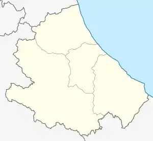 Pescocostanzo Pescocostanzo (Abruzzo) | |
| Coordinates: 41°53′14″N 14°3′59″E / 41.88722°N 14.06639°E | |
| Country | Italy |
| Region | Abruzzo |
| Province | L'Aquila (AQ) |
| Frazioni | Sant'Antonio Bosco |
| Area | |
| • Total | 52.16 km2 (20.14 sq mi) |
| Elevation | 1,395 m (4,577 ft) |
| Population (1 January 2007)[2] | |
| • Total | 1,196 |
| • Density | 23/km2 (59/sq mi) |
| Demonym | Pescolani |
| Time zone | UTC+1 (CET) |
| • Summer (DST) | UTC+2 (CEST) |
| Postal code | 67033 |
| Dialing code | 0864 |
| ISTAT code | 066070 |
| Patron saint | San Felice |
| Saint day | 8 August |
| Website | Official website |
Pescocostanzo is a comune and town of 1038 inhabitants in the Province of L'Aquila in the Abruzzo region of Italy. It is a tourist destination, attracting people from all over Italy due to its landscape and environment. It is part of the Maiella National Park and is one of I Borghi più belli d'Italia ("The most beautiful villages of Italy").[3] In winter, Pescocostanzo is a destination for skiers and snowboarders, and has its own ski resort. The towns of Roccaraso and Rivisondoli are close by.
Images
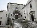 Basilica della Madonna del Colle
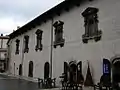 Palazzo Fanzago
See also
References
- ↑ "Superficie di Comuni Province e Regioni italiane al 9 ottobre 2011". Italian National Institute of Statistics. Retrieved 16 March 2019.
- ↑ ISTAT. "Monthly demographic balance January-November 2008". Retrieved 2009-04-27.
- ↑ "Abruzzo" (in Italian). Retrieved 1 August 2023.
External links
Wikimedia Commons has media related to Pescocostanzo.
This article is issued from Wikipedia. The text is licensed under Creative Commons - Attribution - Sharealike. Additional terms may apply for the media files.