Pleasant Mount, Pennsylvania | |
|---|---|
Unincorporated community | |
 The welcome sign for the Village of Pleasant Mount. | |
| Nickname(s): | |
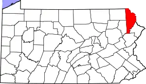
 Pleasant Mount, Pennsylvania Pleasant Mount's Location within Pennsylvania. | |
| Coordinates: 41°44′23″N 75°26′4″W / 41.73972°N 75.43444°W | |
| Country | United States |
| State | Pennsylvania |
| U.S. Congressional District | PA-10 |
| School District | Forest City Regional |
| County | Wayne |
| Magisterial District | 22-3-04[4] |
| Township | Mount Pleasant |
| Settled | June 1789[5] |
| Founded by | Samuel Stanton[5] |
| Named for | Mount Pleasant Township |
| Elevation | 1,982[6] ft (604 m) |
| Time zone | UTC-5 (Eastern (EST)) |
| • Summer (DST) | UTC-4 (Eastern Daylight (EDT)) |
| ZIP codes | 18453[3] |
| Area code | 570 |
| GNIS feature ID | 1184047[6] |
| FIPS code | 42-127-51872[7]-61344[6] |
| Major Roads | |
| Waterways | Biglow Lake,[8] Lackawaxen River (West Branch) |
Pleasant Mount is an unincorporated community in Mount Pleasant Township, Wayne County, Pennsylvania, United States.
References
- ↑ White, Israel Charles; Dolph, John M. (1881). The Geology of Susquehanna County and Wayne County (Report). Vol. 23. Board of Commissioners for the Second Geological Survey of Pennsylvania. p. 59. Retrieved January 30, 2016.
- ↑ White & Dolph. p. 170.
- 1 2 "Look up a ZIP Code". USPS.COM. USPS. 2014. Retrieved January 30, 2016.
- ↑ "District Magistrate". Wayne County, PA. Wayne County Courthouse. 2014. Archived from the original on November 27, 2014. Retrieved January 30, 2016.
- 1 2 Whaley, Samuel (1856). History of the Township of Mount Pleasant, Wayne County, Pennsylvania. A Discourse Delivered on Thanksgiving Day, November 22, 1855. New York: M. W. Dodd. p. 9.
- 1 2 3 "Pleasant Mount". Geographic Names Information System. United States Geological Survey, United States Department of the Interior. August 2, 1979. Retrieved January 30, 2016.
- ↑
U.S. Census Bureau. Census 2000. "Census Demographic Profiles, Mount Pleasant Township" (PDF). CenStats Databases. Retrieved January 30, 2016.
{{cite web}}: CS1 maint: numeric names: authors list (link) - ↑ "Biglow Lake". Geographic Names Information System. United States Geological Survey, United States Department of the Interior. August 2, 1979. Retrieved February 18, 2016.
This article is issued from Wikipedia. The text is licensed under Creative Commons - Attribution - Sharealike. Additional terms may apply for the media files.
