Portnashangan
Port na Seangán | |
|---|---|
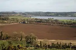
 Fields in Mountmurray townland on the northern shores of Lough Owel | |
 Portnashangan Location of Portnashangan within County Westmeath in the Republic of Ireland | |
| Coordinates: 53°35′3″N 7°22′49″W / 53.58417°N 7.38028°W | |
| Country | Ireland |
| Province | Leinster |
| County | County Westmeath |
| Irish grid reference | N411595 |
Portnashangan (Irish: Port na Seangán)[1] is a civil parish in County Westmeath, Ireland. It is located about 7 kilometres (4 mi) north-north–west of Mullingar on both sides of Lough Owel.
Portnashangan is one of 8 civil parishes in the barony of Corkaree in the Province of Leinster. The civil parish covers 3,621.8 acres (14.657 km2).

Portnashangan civil parish comprises 8 townlands: Ballynafid, Ballynagall Clanhugh Demesne, Loughanstown, Mountmurray, Piercefield, Portnashangan and Rathlevanagh. Of these, Mountmurray and Piercefield lie west of Lough Owel, the others to the east of the lake. The two parts of the parish have no land connection and are separated by the area of Leny parish.
The neighbouring civil parishes are: Stonehall and Tyfarnham to the north, Rathconnell (barony of Moyashel and Magheradernon) to the east, Mullingar (Moyashel and Magheradernon) and Portloman to the south and Leny to the east.[2][3]
References
- ↑ Portnashangan civil parish Logainm.ie Retrieved on 12 June 2015.
- ↑ Portnashangan civil parish, Co. Westmeath Townlands.ie Retrieved on 12 June 2015.
- ↑ Portnashangan civil parish, Co. Westmeath The IreAtlas Townland Data Base Retrieved on 12 June 2015.
External links
- Portnashangan civil parish at the IreAtlas Townland Data Base
- Portnashangan civil parish at Townlands.ie
- Portnashangan civil parish at Logainm.ie
