Highway 119 | ||||
|---|---|---|---|---|
| Ruta 119 | ||||
| Route information | ||||
| Maintained by Puerto Rico DTPW | ||||
| Length | 79.7 km[1][2][3] (49.5 mi) | |||
| Existed | 1953[4]–present | |||
| Major junctions | ||||
| South end | ||||
| ||||
| North end | ||||
| Location | ||||
| Country | United States | |||
| Territory | Puerto Rico | |||
| Municipalities | San Germán, Maricao, Mayagüez, Las Marías, San Sebastián, Isabela, Quebradillas, Camuy, Hatillo | |||
| Highway system | ||||
| ||||
| ||||


Puerto Rico Highway 119 (PR-119) is a long north-to-south highway in Puerto Rico that goes from Puerto Rico Highway 2 in Hatillo, close to its border with Camuy to the same highway in San Germán. It goes through the municipalities of Camuy, San Sebastián, Las Marías and Maricao before ending in the freeway segment of PR-2. Between Camuy and San Sebastián it passes near Guajataca Lake, the largest artificial lake in western Puerto Rico.[5][6]
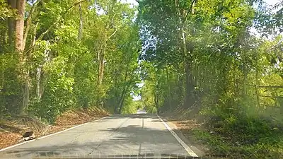 Puerto Rico Highway 119 south in Aibonito, San Sebastián
Major intersections
 Sign for intersection of Puerto Rico Highways 119 and 125 in San Sebastián
 PR-119 intersection with PR-435
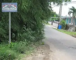 Sign for Perchas 1 barrio on PR-435 leaving PR-119
| Municipality | Location | km [1][2][3] | mi | Destinations | Notes | |||
|---|---|---|---|---|---|---|---|---|
| San Germán | Caín Bajo | 79.7 | 49.5 | Southern terminus of PR-119; PR-2 exit 172; diamond interchange | ||||
| 78.0 | 48.5 | |||||||
| Caín Bajo–Hoconuco Alto line | 76.2 | 47.3 | ||||||
| Hoconuco Alto–Hoconuco Bajo line | 75.3 | 46.8 | ||||||
| Rosario Alto | 72.3 | 44.9 | ||||||
| Maricao | Montoso | 63.5 17.4[lower-alpha 1] | 39.5 10.8 | Southern terminus of PR-105 concurrency | ||||
| Mayagüez | Montoso | 15.6[lower-alpha 1] 63.4 | 9.7 39.4 | Northern terminus of PR-105 concurrency | ||||
| 61.4 | 38.2 | Southern terminus of the Ruta Panorámica concurrency | ||||||
| Naranjales | 59.9 13.7[lower-alpha 2] | 37.2 8.5 | Western terminus of PR-106 concurrency | |||||
| Mayagüez–Las Marías municipal line | Montoso–Naranjales line | 14.3[lower-alpha 2] 59.8 | 8.9 37.2 | Eastern terminus of PR-106 concurrency; northern terminus of the Ruta Panorámica concurrency | ||||
| Las Marías | Furnias–Río Cañas line | 54.7– 54.6 | 34.0– 33.9 | |||||
| Furnias | 53.9 | 33.5 | ||||||
| 51.3 | 31.9 | |||||||
| Las Marías barrio-pueblo | 49.3 | 30.6 | ||||||
| San Sebastián | Guacio–Calabazas line | 42.3 | 26.3 | |||||
| Calabazas–Culebrinas line | 41.6 | 25.8 | ||||||
| 38.4 | 23.9 | |||||||
| 36.4 | 22.6 | |||||||
| Piedras Blancas | 35.2 19.9[lower-alpha 3] | 21.9 12.4 | Eastern terminus of PR-125 concurrency; former PR-111R | |||||
| Piedras Blancas–Bahomamey line | 19.7[lower-alpha 3] 35.1 | 12.2 21.8 | Western terminus of PR-125 concurrency | |||||
| San Sebastián barrio-pueblo | 34.7 | 21.6 | One-way street | |||||
| Piedras Blancas–Bahomamey line | 34.2– 34.1 | 21.3– 21.2 | ||||||
| Hoya Mala | 28.9 | 18.0 | ||||||
| Hoya Mala–Guajataca line | 26.6 | 16.5 | ||||||
| Aibonito–Guajataca line | 24.6 | 15.3 | ||||||
| Aibonito | 21.7 | 13.5 | ||||||
| Isabela |
No major junctions | |||||||
| Quebradillas | Guajataca | 19.0 | 11.8 | |||||
| 16.9 | 10.5 | |||||||
| Camuy | Piedra Gorda–Puertos line | 15.4 | 9.6 | |||||
| Piedra Gorda | 14.5 | 9.0 | ||||||
| 13.2 | 8.2 | |||||||
| 12.7 | 7.9 | |||||||
| Puente | 5.9 | 3.7 | ||||||
| Puente–Camuy barrio-pueblo line | 5.1 2.3[lower-alpha 4] | 3.2 1.4 | Southern terminus of PR-4491 concurrency | |||||
| 2.2[lower-alpha 4] 5.0 | 1.4 3.1 | Northern terminus of PR-4491 concurrency | ||||||
| Camuy barrio-pueblo | 3.7 | 2.3 | Former PR-485; one-way street | |||||
| Hatillo | Hatillo barrio-pueblo | 1.6 | 0.99 | One-way street | ||||
| Hatillo barrio-pueblo–Hatillo line | 0.0 | 0.0 | Northern terminus of PR-119 | |||||
1.000 mi = 1.609 km; 1.000 km = 0.621 mi
| ||||||||
- 1 2 Kilometer markers represent the distance along PR-105 rather than PR-119.
- 1 2 Kilometer markers represent the distance along PR-106 rather than PR-119.
- 1 2 Kilometer markers represent the distance along PR-125 rather than PR-119.
- 1 2 Kilometer markers represent the distance along PR-4491 rather than PR-119.
Related route
Highway 4119 | |
|---|---|
| Location | Quebradillas – Camuy |
| Length | 7.3 km[7] (4.5 mi) |
Puerto Rico Highway 4119 (PR-4119) is the old section of PR-485 through Camuy, Puerto Rico. It is a parallel road to the Atlantic coast that runs from downtown Camuy to the Quebradillas municipal limit.[8]
| Municipality | Location | km[7] | mi | Destinations | Notes |
|---|---|---|---|---|---|
| Quebradillas | San José | 7.3 | 4.5 | Western terminus of PR-4119 | |
| Camuy | Camuy barrio-pueblo | 0.0 | 0.0 | Eastern terminus of PR-4119 | |
| 1.000 mi = 1.609 km; 1.000 km = 0.621 mi | |||||
See also
References
- 1 2 Google (26 March 2020). "PR-119 north" (Map). Google Maps. Google. Retrieved 26 March 2020.
- 1 2 Google (26 March 2020). "PR-119 central" (Map). Google Maps. Google. Retrieved 26 March 2020.
- 1 2 Google (26 March 2020). "PR-119 south" (Map). Google Maps. Google. Retrieved 26 March 2020.
- ↑ "Quebradillas, Memoria Núm. 62" (PDF). Puerto Rico Planning Board (in Spanish). 1955. Retrieved 11 August 2020.
- ↑ National Geographic Maps (2011). Puerto Rico (Map). 1:125,000. Adventure Map (Book 3107). Evergreen, Colorado: National Geographic Maps. ISBN 978-1566955188. OCLC 756511572.
- ↑ "Tránsito Promedio Diario (AADT)". Transit Data (Datos de Transito) (in Spanish). DTOP PR. pp. 67–68. Archived from the original on 1 April 2019.
- 1 2 Google (1 March 2020). "PR-4119" (Map). Google Maps. Google. Retrieved 1 March 2020.
- ↑ "Causa estragos severos en varias carreteras el fuerte oleaje - Jornada Noticiosa - Jornada PR - Noticias Puerto Rico". Jornada Noticiosa - Jornada PR - Noticias Puerto Rico (in Spanish). Retrieved 12 April 2019.
External links
Wikimedia Commons has media related to Puerto Rico Highway 119 and Puerto Rico Highway 4119.
This article is issued from Wikipedia. The text is licensed under Creative Commons - Attribution - Sharealike. Additional terms may apply for the media files.