Route 137 | ||||
|---|---|---|---|---|
 | ||||
| Route information | ||||
| Maintained by Transports Québec | ||||
| Length | 59.9 km[1] (37.2 mi) | |||
| Major junctions | ||||
| South end | ||||
in Saint-Hyacinthe | ||||
| North end | ||||
| Location | ||||
| Country | Canada | |||
| Province | Quebec | |||
| Highway system | ||||
| ||||

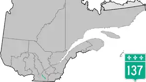
Route 137 is a north/south highway on the south shore of the Saint Lawrence River in Quebec, Canada. Its northern terminus is in Saint-Denis-sur-Richelieu, at the junction of Route 133, and the southern terminus is in Granby at the junction of Route 112.
Municipalities along Route 137
Major intersections
| RCM or ET | Municipality | Km | Junction | Notes |
|---|---|---|---|---|
Southern terminus of Route 137 | ||||
| La Haute-Yamaska | Granby | 0.0 | 112 WEST: to Saint-Paul-d'Abbotsford 112 EAST: to Shefford | |
| Sainte-Cecile-de-Milton | 8.5 | 211 NORTH: to Saint-Valérien-de-Milton | ||
| Les Maskoutains | Saint-Hyacinthe | 29.1 | 224 EAST: to Saint-Simon | |
| 30.9 31.5 |
116 EAST: to Saint-Simon 116 WEST: to Sainte-Marie-Madeleine | |||
| 33.5 | 235 SOUTH: to Saint-Pie | |||
| 33.9 34.3 |
20 EAST: to Saint-Simon 20 WEST: to La Présentation | |||
| 35.1 | 235 NORTH: to Saint-Barnabe-Sud | |||
| La Vallée-du-Richelieu | Saint-Denis-sur-Richelieu | 59.9 | 133 SOUTH: to Mont-Saint-Hilaire 133 NORTH: to Saint-Ours | |
Northern terminus of Route 137 | ||||
See also
References
- ↑ Ministère des transports, "Distances routières", page 66, Les Publications du Québec, 2005
External links
- Provincial Route Map (Courtesy of the Quebec Ministry of Transportation) (in French)
- Route 137 on Google Maps
This article is issued from Wikipedia. The text is licensed under Creative Commons - Attribution - Sharealike. Additional terms may apply for the media files.