Route 173 | ||||
|---|---|---|---|---|
 | ||||
| Route information | ||||
| Maintained by Transports Québec | ||||
| Length | 142.4 km[1] (88.5 mi) | |||
| History | ||||
| Major junctions | ||||
| South end | ||||
| North end | ||||
| Location | ||||
| Country | Canada | |||
| Province | Quebec | |||
| Major cities | Lévis, Saint-Georges, Sainte-Marie, Vallée-Jonction, Beauceville | |||
| Highway system | ||||
| ||||

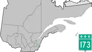
Route 173 (Route-du-Président-Kennedy) is a major north/south highway on the south shore of the St. Lawrence River in Quebec, Canada, named after the assassinated American president, John F. Kennedy. Its southern terminus is at the Armstrong-Jackman Border Crossing in Saint-Théophile in the hamlet of Armstrong, at the border with Maine (U.S. Route 201 / Maine SR 6), and its northern terminus is in Lévis at the junction of Route 132. Route 173 follows the Chaudière River for most of its course, from Saint-Georges, down to Scott, where the route takes a more northeastern route towards Lévis, crossing the Etchemin River in the municipality of Saint-Henri-de-Lévis.
Municipalities along Route 173
- Saint-Côme-Linière
- Saint-Georges
- Notre-Dame-des-Pins
- Beauceville
- Saint-Joseph-de-Beauce
- Vallée-Jonction
- Sainte-Marie
- Scott
- Saint-Isidore
- Saint-Henri
- Lévis
.jpg.webp)
Quebec Route 173 in Pintendre
Major intersections
| RCM | Location | km[1] | mi | Destinations | Notes |
|---|---|---|---|---|---|
| Beauce-Sartigan | Saint-Théophile | 0.0 | 0.0 | Continuation into Maine | |
| Armstrong–Jackman Border Crossing | |||||
| 17.0 | 10.6 | ||||
| Saint-Côme–Linière | 31.3 | 19.4 | |||
| Saint-Georges | 43.3 | 26.9 | South end of R-204 concurrency | ||
| 46.5 | 28.9 | ||||
| 47.6 | 29.6 | North end of R-204 concurrency; to A-73 southern terminus | |||
| Beauce-Centre | Beauceville | 62.4 | 38.8 | ||
| Saint-Joseph-de-Beauce | 74.3 | 46.2 | South end of R-276 concurrency | ||
| 76.7 | 47.7 | North end of R-276 concurrency | |||
| La Nouvelle-Beauce | Vallée-Jonction | 85.6 | 53.2 | South end of R-112 concurrency | |
| 85.9 | 53.4 | North end of R-112 concurrency | |||
| Sainte-Marie | 95.9 | 59.6 | South end of R-216 concurrency | ||
| 97.5 | 60.6 | North end of R-216 concurrency | |||
| Scott | 105.2 | 65.4 | |||
| 106.1 | 65.9 | A-73 exit 101 | |||
| Route Carrier | To R-175 north | ||||
| Saint-Isidore | 114.5 | 71.1 | South end of R-275 concurrency | ||
| Saint-Henri | 124.4 | 77.3 | South end of R-218 concurrency | ||
| 124.8 | 77.5 | North end of R-275 concurrency | |||
| 127.9 | 79.5 | North end of R-218 concurrency | |||
| 128.9 | 80.1 | Roundabout | |||
| Lévis | 140.2– 140.7 | 87.1– 87.4 | A-73 exit 101 | ||
| To Lévis–Québec ferry | |||||
| 142.4 | 88.5 | R-173 northern terminus | |||
| 143.0 | 88.9 | Rue Saint-Georges | Route-du-Président-Kennedy northern terminus | ||
1.000 mi = 1.609 km; 1.000 km = 0.621 mi
| |||||
See also
References
- 1 2 Google (April 21, 2023). "Quebec Route 173" (Map). Google Maps. Google. Retrieved April 21, 2023.
External links
- Provincial Route Map (Courtesy of the Quebec Ministry of Transportation) (in French)
- Route 173 on Google Maps
This article is issued from Wikipedia. The text is licensed under Creative Commons - Attribution - Sharealike. Additional terms may apply for the media files.