Route 337 | ||||
|---|---|---|---|---|
 | ||||
| Route information | ||||
| Maintained by Transports Québec | ||||
| Length | 80.0 km[1] (49.7 mi) | |||
| Major junctions | ||||
| South end | ||||
| North end | ||||
| Location | ||||
| Country | Canada | |||
| Province | Quebec | |||
| Major cities | Terrebonne, Mascouche, Saint-Lin-Laurentides, Saint-Jean-de-Matha | |||
| Highway system | ||||
| ||||

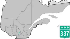
Route 337 is a Quebec provincial highway situated in the Lanaudière region. It runs from the junctions of Autoroute 25 and Route 344 in Terrebonne (north of Laval and Montreal) and ends in Saint-Jean-de-Matha at Route 131. It overlaps Route 335 and Route 158 near Saint-Lin–Laurentides as well as Route 125 in Sainte-Julienne, Route 341 and Route 348 in Rawdon and Route 343 in Saint-Alphonse-Rodriguez.
Municipalities along Route 337
.jpg.webp)
Quebec Route 337 in Sainte-Julienne
See also
References
- ↑ Ministère des transports, "Distances routières", page 98, Les Publications du Québec, 2005
External links
- Transports Quebec Official Map (in French)
- Route 337 on Google Maps
This article is issued from Wikipedia. The text is licensed under Creative Commons - Attribution - Sharealike. Additional terms may apply for the media files.