District XVII of Budapest
(Rákosmente) Budapest XVII. kerülete | |
|---|---|
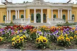     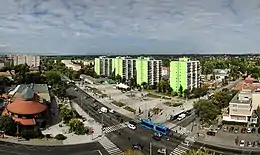 Clockwise from top: Podmaniczky–Vigyázó Mansion, Our Lady of Hungary Church in Rákosliget, Mansion of Gyula Gózon, Rákosmente City Center, Árpád Csekovszky cultural center, Rákoskert Avenue | |
 Flag  Coat of arms | |
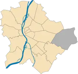 Location of District XVII in Budapest (grey) | |
| Coordinates: 47°28′49″N 19°16′00″E / 47.4803°N 19.2667°E | |
| Country | |
| Region | Central Hungary |
| City | Budapest |
| Established | 1 January 1950 |
| Named for | Rákos Stream |
| Neighborhoods[1] | List
|
| Government | |
| • Mayor | Tamás Horváth (Fidesz-KDNP) |
| Area | |
| • Total | 54.82 km2 (21.17 sq mi) |
| • Rank | 1st |
| Highest elevation | 241 m (791 ft) |
| Population (2020)[2] | |
| • Total | 87 388[3] |
| • Rank | 7th |
| • Density | 1,601/km2 (4,150/sq mi) |
| Demonym | tizenhetedik kerületi ("17th districter") |
| Postal code | 1171 ... 1174 |
| Website | Official Website of Rákosmente |
District XVII of Budapest (known as Rákosmente) is a suburban district of Budapest on the left bank of the Danube, in the eastern part of the capital. It is Budapest's largest district, with an area of 54.82 km2, and home to nearly 90,000 people, making it the seventh most populous district of Budapest. Towns that were different in nature, but closely connected, were annexed to the capital in 1950 as part of the Greater Budapest plan. It is one of the most beautifully located districts of Pest, which is partly located as high as the 235 meters Gellért Hill. As the district is part of the Pest Plain, which gradually rises from the Danube to the east, the district's area is almost entirely hilly. The 241 meter high Erdő Hill, the highest point of the Pest side and the Pest Plain is also located here.[4]
The majority of the district is green area, in terms of per capita green and forest areas, the 2nd district of Budapest, the Hegyvidék and as well District XVII is the best-served districts of the capital. There are several nature reserves in its area, such as the 40-hectare Merzse-marsh full of plant rarities and rich birdlife, the vast green area of the Keresztúr Forest,[5] and Lake Naplás, the second largest nature reserve in Budapest with 150 hectares, is also one of the most valuable ecological areas in the area.
District XVII was the most popular district of Budapest according to the moves in 2019, 1045 more people settled here down than who moved out.[6] The population of the suburban district growth as a result of suburbanization and still increasing today, despite the fact that the population of Budapest has decreased by hundreds of thousands in recent decades. Due to the population growth, new housing estates areas were built on previously green or agricultural areas, and the existing ones were expanded.
The district has high level of public transport supply, with ![]() 67, 97E, 161, 161A, 169E, 261E bus lines taking 15–20 minutes from the western part of the district and around 25 minutes from the eastern part to arrive directly to Örs vezér tere and to
67, 97E, 161, 161A, 169E, 261E bus lines taking 15–20 minutes from the western part of the district and around 25 minutes from the eastern part to arrive directly to Örs vezér tere and to ![]() Metro Line M2, while with
Metro Line M2, while with ![]() 68, 201E, 202E buses Kőbánya-Kispest metro station and
68, 201E, 202E buses Kőbánya-Kispest metro station and ![]() Metro Line M3 is directly accessible. The area is easily accessible from the city center at night with
Metro Line M3 is directly accessible. The area is easily accessible from the city center at night with ![]() 956 and 990 night buses, which covering almost the entire district. In addition, there are six train stops in the immediate vicinity of the residential areas, from where can be reached the Budapest Keleti railway station in 15 minutes with modern suburban trains.[7]
956 and 990 night buses, which covering almost the entire district. In addition, there are six train stops in the immediate vicinity of the residential areas, from where can be reached the Budapest Keleti railway station in 15 minutes with modern suburban trains.[7]
Neighbourhoods
The names of the neighbourhoods in Rákosmente come from the names of the original villages, adding the newly built neighbourhoods as well:
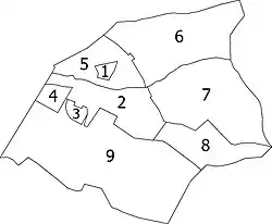
- Régiakadémiatelep (1930s)
- Rákoskeresztúr (13th century)
- Madárdomb (1984)
- Akadémiaújtelep (1950s)
- Rákosliget (1896)
- Rákoscsaba-Újtelep (1925)
- Rákoscsaba (11th century)
- Rákoskert (1933)
- Rákoshegy (1892)
Location
It is one of the most beautifully located districts of Pest, which is partly as high as Gellért Hill. As it is part of the Pest alluvial plain, which gradually rises east of the Danube within the Pest Plain, its area is almost entirely hilly. The Pest side and at the same time the highest point of the Pest plain, Erdő-hegy, is also located here at the easternmost residential meeting of Rákoskert and Rákoscsaba, along Pesti út. Its height is 241 meters (Gellért Hill is 235 meters). From the eastern border of the district, the slopes of the Gödöllő Hills start to the north and the Monor – Irsai Hills to the south. Rákosmente with its area of 54.83 km2, is more than 25 times larger than the smallest district; Erzsébetváros "Elisabethtown" (7th).
Rákosmente is bordered by the 16th district to the northwest, by the 10th district to the west, by the 18th district to the southwest, by Ecser and Maglód to the southeast, by Pécel to the east and by Nagytarcsa to the northeast.
Economy
In terms of economy, Rákosmente belongs to the most developed part of Hungary, the Central Hungary region. Rákosmente is an important supply center of the Budapest metropolitan area, and attracts the surrounding settlements (Ecser, Maglód, Pécel) to provides administrative service, public cultural services and health functions as well. There are two major industrial facilities (DAF Trucks, Volvo) and one fruit processing plant (Rauch) in Rákosmente. The agricultural activity in the district is negligible.
In 2011, 7,169 operating enterprises were registered in Rákosmenten, and the local economy is primarily dominated by service firms. From local firms 791 were retail stores, of which 133 were grocery stores, 127 food specialty stores, and 406 were non-food retail specialty stores. The number of petrol stations in the district in 2011 was 14 and the number of vehicle shops was 65. There are three operating markets and trade fairs in the district, of which one is municipally owned and two are privately owned. The number of restaurants was 191 in the district.[8]
According to the 2011 census, 56.0% of the people living in Rákosmente work outside the district, this ratio is equal to the average commuting data of the districts of Budapest. The commuting time of the residents to work is 39.5 minutes on average, only slightly higher than in the case of the inner districts, which showed a value of 36 minutes.[8]
Most of the neighbourhoods of Rákosmente has no significant variance in the social composition and employment indicators. The economic characteristic of the population of the newly built Madárdomb and the population living on the outskirts differ significantly. While Madárdomb is a young part of the settlement, the inhabitants of it mostly came from the upper-middle class segments, understandably all indicators (employment, education) show an outstanding value, while in the outskirts they are significantly worse. The biggest positive difference is in case of Madárdomb, where the proportion of people with higher education is 46.7%, twice the district average and more than five times higher, than the peripheral indicator.[9]
Population
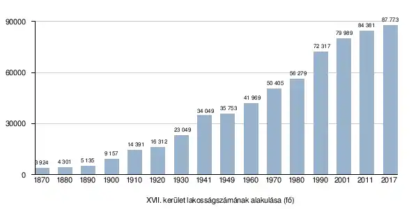
The district was established on January 1, 1950. Data from 1949 and earlier are the total population of former municipalities in the district.
| Year | Pop. | ±% p.a. |
|---|---|---|
| 1870 | 3,924 | — |
| 1880 | 4,301 | +0.92% |
| 1890 | 5,135 | +1.79% |
| 1900 | 9,157 | +5.95% |
| 1910 | 14,391 | +4.62% |
| 1920 | 16,312 | +1.26% |
| 1930 | 23,049 | +3.52% |
| 1941 | 34,876 | +3.84% |
| 1949 | 35,753 | +0.31% |
| 1960 | 41,969 | +1.47% |
| 1970 | 50,405 | +1.85% |
| 1980 | 56,279 | +1.11% |
| 1990 | 72,317 | +2.54% |
| 2001 | 79,989 | +0.92% |
| 2011 | 84,381 | +0.54% |
| 2017 | 87,773 | +0.66% |
Sport
The association football club, Rákosmenti KSK, is based in Rákosmente.
List of mayors
| Member | Party | Date | |
|---|---|---|---|
| József Dóczy | SZDSZ | 1990–1994 | |
| Péter Kátai | SZDSZ | 1994–1998 | |
| Katalin Devánszkiné Molnár | MSZP | 1998–2002 | |
| Attila Hoffmann | MSZP | 2002–2006 | |
| Levente Riz | Fidesz | 2006–2019 | |
| Tamás Horváth | Fidesz | 2019– | |
Gallery
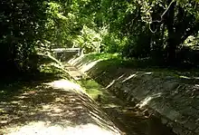 The 44 km long Rákos Stream which estuary to Danube, from the name Rákosmente is derived
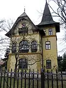 Erdős Renée mansion at Rákoshegy
 Gregor József Primary School in Rákosliget
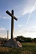 The 201 meters high Vida Hill, one of the most beautiful panoramas of Pest side opens from the it
.jpg.webp) The monumental Church of the Holy Cross, built in 1894, in the square of the same name along the Pesti út
The monumental Church of the Holy Cross, built in 1894, in the square of the same name along the Pesti út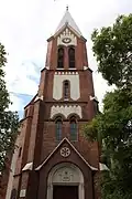 Reformed Church built in 1905, in Rákoscsaba neighbourhood
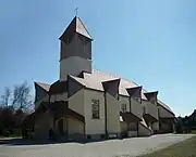 Catholic Church of St. Paul, completed in 2000, in Madárdomb neighbourhood
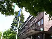 The Town hall of Rákosmente in the city center
 Renovated city center of the district
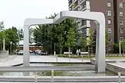 Waterwork in the Main Square of Rákosmente
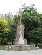 Trianon memorial along the Pesti út in People's Garden
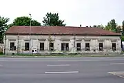 The currently abandoned Bulyovszky mansion, the birthplace of Gyula Bulyovszky, one of the leader of Hungarian Revolution of 1848
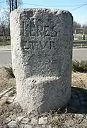 Rákoskeresztúr and Pest, Hungary borderstone from 1738 at Akadémiaújtelep neighbourhood
 Birdwatching lookout at the fifth stop of the Merzse-marsh hiking trail
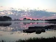
 Rákosmente and its surroundings in a 1940 aerial photograph
Notable people
- Csaba Abaházi, radio presenter
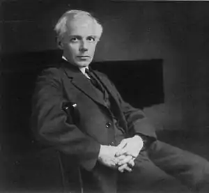
- Béla Bartók, composer, pianist, and ethnomusicologist
- Berky Lili, actress
- Ákos Buzsáky, football
- Renée Erdős, poet, novelist
- Gyula Gózon, actor
- György Kiss, Mihály Munkácsy Prize painter, sculptor, medalist
- Krencsey Marianne, actress
- Monika Laborcz, ceramicist
- Endre Mányoky, journalist
- Harghita Mecsek, sculptor and graphic artist
- Kristóf Nyíri, philosopher
- Gyula Radnai, physicist
- Elemér Ragályi, cameraman
- S. István Nagy, lyricist
- Béla Soós, reformed theologian, church historian
- István Szilágyi, actor
- László Bényi, painter
- Zoltán Sztancsek, geologist, superintendent of the city of Budapest, former director of the Department Museum
- Ferenc Vigyázó, Hungarian politician, member of the upper house, legal writer
- Jozsef Gregor, operatic bass
- Tibor Bitskey, actor
- János Kodolányi, writer
- László Rédei, mathematician
- Franz von Vecsey, violinist and composer virtuoso
Notes
References
- ↑ "94/2012. (XII. 27.) Főv. Kgy. rendelet - a közterület- és városrésznevek megállapításáról, azok jelöléséről, valamint a házszám-megállapítás szabályairól" (in Hungarian).
- 1 2 "A fővárosi kerületek, a megyei jogú városok, a városok területe, lakónépessége és a lakások száma" [The area of districts of the capital, of the towns with county's rights, resident population and number of dwellings]. Magyarország közigazgatási helynévkönyve 2016. január 1 [Gazetteer of Hungary 1 January 2016] (PDF). Hungarian Central Statistical Office. 2016. p. 21.
- ↑ https://www.ksh.hu/apps/hntr.telepules?p_lang=HU&p_id=02112 Budapest 17. kerület Alapadatok
- ↑ Rákosmente 2015–2030 Settlement Development Concept - 2.1 Introduction
- ↑ Keresztúr Forest renewed with a running circuit, training park and cauldron clearings in Rákosmente
- ↑ It turned out which are the most popular districts of Budapest
- ↑ https://www.mavcsoport.hu/sites/default/files/upload/page/120a_20201213_v1202.pdf 120a Budapest — Újszász — Szolnok
- 1 2 Rákosmente 2015–2030 Settlement Development Concept - 2.2.2 Economy
- ↑ Rákosmente Settlement Development Strategy Foundation, page 80
- ↑ "Magyar települések lakosságszámának alakulása". Magyarország. Retrieved 1 January 2018.
