 | |
|---|---|
| Bóthar R259 | |
 Glashbeggan: looking southeast along the R259 | |
| Route information | |
| Length | 24.3 km (15.1 mi) |
| Major junctions | |
| From | |
| |
| To | |
| Location | |
| Country | Ireland |
| Highway system | |
The R259 road is a regional road in Ireland, located in County Donegal. It is a scenic route around the coast of The Rosses, which connects with N56 at both ends.[1][2][3]

R259 in Kincasslagh village as it turns south towards Dungloe
The road runs east from Crolly to Kincasslagh, where it turns south to Dungloe, becoming the lower half of Dungloe Main Street before again connecting with N56 on Carnmore Road.
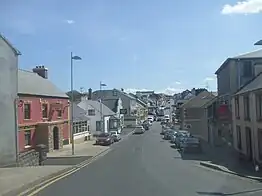
R259 at its southern end where it multiplexes with Dungloe Main Street
The road forms part of the Wild Atlantic Way.
References
- ↑ "R259". Roader's Digest: The SABRE Wiki. SABRE. Retrieved 9 March 2016.
- ↑ "S.I. No. 54/2012 - Roads Act 1993 (Classification of Regional Roads) Order 2012". irishstatutebook.ie. Retrieved 9 March 2016.
- ↑ "Glenahilt, Burtonport, Co. Donegal - Property.ie". www.property.ie.
55°01′06″N 8°19′52″W / 55.018276°N 8.331081°W
This article is issued from Wikipedia. The text is licensed under Creative Commons - Attribution - Sharealike. Additional terms may apply for the media files.