 | |
|---|---|
| Bóthar R459 | |
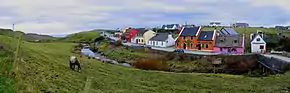 Panorama of Fisher Street, part of the R459. | |
| Route information | |
| Length | 2.2 km (1.4 mi) |
| Major junctions | |
| From | Doolin Pier |
| Crosses Aille River | |
| To | |
| Location | |
| Country | Ireland |
| Highway system | |
The R459 road is a regional road in Ireland, located in Doolin, County Clare.[1][2]
References
- ↑ "R459 - Roader's Digest: The SABRE Wiki". Archived from the original on 7 March 2016. Retrieved 24 February 2016.
- ↑ "Electronic Irish Statute Book (eISB)". Archived from the original on 7 March 2016. Retrieved 24 February 2016.
This article is issued from Wikipedia. The text is licensed under Creative Commons - Attribution - Sharealike. Additional terms may apply for the media files.