Prague 16
Praha 16 | |
|---|---|
 Radotín | |
 Flag  Coat of arms | |
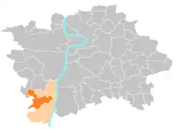
 Location of Prague 16 in Prague | |
| Coordinates: 49°59′3″N 14°21′28″E / 49.98417°N 14.35778°E | |
| Country | |
| Region | Prague |
| Government | |
| • Mayor | Karel Hanzlík |
| Area | |
| • Total | 9.31 km2 (3.59 sq mi) |
| Population (2021)[1] | |
| • Total | 8,462 |
| • Density | 910/km2 (2,400/sq mi) |
| Time zone | UTC+1 (CET) |
| • Summer (DST) | UTC+2 (CEST) |
| Postal code | 153 00 |
| Website | www |
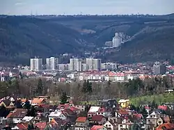
Prague 16 is a municipal district (městská část) of Prague. It has about 8,500 inhabitants. It is located in the south-western part of the city. It is formed by one cadastre, Radotín.
The administrative district (správní obvod) of the same name consists of municipal districts Prague 16, Lipence, Lochkov, Velká Chuchle and Zbraslav.
| Year | Pop. | ±% |
|---|---|---|
| 1869 | 494 | — |
| 1880 | 628 | +27.1% |
| 1890 | 944 | +50.3% |
| 1900 | 1,273 | +34.9% |
| 1910 | 1,800 | +41.4% |
| 1921 | 2,276 | +26.4% |
| 1930 | 4,704 | +106.7% |
| 1950 | 5,349 | +13.7% |
| 1961 | 6,152 | +15.0% |
| 1970 | 6,813 | +10.7% |
| 1980 | 6,399 | −6.1% |
| 1991 | 7,053 | +10.2% |
| 2001 | 7,089 | +0.5% |
| 2011 | 8,486 | +19.7% |
| 2021 | 8,462 | −0.3% |
| Source: Censuses[2][3] | ||
See also

Radotín valley in 1914
References
- ↑ "Výsledky Sčítání 2021 – městské části hl. m. Prahy" (in Czech). Czech Statistical Office. Retrieved 2022-10-10.
- ↑ "Historický lexikon obcí České republiky 1869–2011 – Praha" (in Czech). Czech Statistical Office. 2015-12-21. pp. 7–8.
- ↑ "Population Census 2021: Population by sex". Public Database. Czech Statistical Office. 2021-03-27.
External links
Wikimedia Commons has media related to Prague 16.
This article is issued from Wikipedia. The text is licensed under Creative Commons - Attribution - Sharealike. Additional terms may apply for the media files.