Rangárþing ytra | |
|---|---|
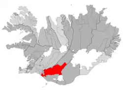 Location of Rangárþing ytra | |
| Country | Iceland |
| Region | Southern Region |
| Constituency | South Constituency |
| Established | 9 June 2002 |
| Government | |
| • Manager | Ágúst Sigurðsson |
| Area | |
| • Total | 3,188 km2 (1,231 sq mi) |
| Population | |
| • Total | 1,553 |
| • Density | 0.49/km2 (1.3/sq mi) |
| Postal code(s) | 850, 851 |
| Municipal number | 8614 |
| Website | ry |
Rangárþing ytra (Icelandic pronunciation: [ˈrauŋkˌaurˌθiŋk ˈɪːtra] ⓘ) is a municipality located in southern Iceland. Its major industries include tourism and agriculture. Rangárþing ytra was created 9 June 2002, when three municipalities, Rangárvallahreppur, Holta- og Landsveit and Djúpárhreppur were merged. The largest settlement is Hella.
Villages
References
External links
- Official site (in Icelandic)
This article is issued from Wikipedia. The text is licensed under Creative Commons - Attribution - Sharealike. Additional terms may apply for the media files.