Rangpur Sadar
রংপুর সদর | |
|---|---|
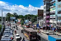
 Shahid Mukhtar Elahi intersection in Rangpur | |
.svg.png.webp) | |
| Coordinates: 25°45.5′N 89°14′E / 25.7583°N 89.233°E | |
| Country | |
| Division | Rangpur |
| District | Rangpur |
| Headquarters | Rangpur |
| Area | |
| • Total | 359.48 km2 (138.80 sq mi) |
| Population (2011) | |
| • Total | 718,203 |
| • Density | 2,000/km2 (5,200/sq mi) |
| Demonym(s) | Rangpuri, Rongpuri |
| Time zone | UTC+6 (BST) |
| Website | Official Map of Rangpur Sadar |
Rangpur Sadar (Bengali: রংপুর সদর) is an Upazila of Rangpur District in the Division of Rangpur, Bangladesh.[1] Its headquarters are in Rangpur.
Geography
Rangpur Sadar Upazila is located at 25°45′30″N 89°14′00″E / 25.7583°N 89.2333°E. It has 165,017 households and total area 359.48 km2.
The padas of Rangpur Sadar are Dhaap, Kamal Kasna, Robertsonganj, Mondolpara, Kuthirpara, Bahar Kasna, Munshipara, Mulatole Pada, Keranipara, Gomostapara, New Engineer Pada, Kotkipara, Deudoba Dangirpara, Palapara (also named Pakpara), Lalbagh. Mominpur is one of the unions in Rangpur Sadar upazila.
Demographics
According to the 2011 Bangladesh census, Rangpur Sadar Upazila had 165,017 households and a population of 718,203. 146,409 (20.39%) were under 10 years of age. Rangpur Sadar had a literacy rate (age 7 and over) of 60.99%, compared to the national average of 51.8%, and a sex ratio of 958 females per 1000 males. 300,659 (41.86%) lived in urban areas.[2][3]
As of the 1991 Bangladesh census, Rangpur Sadar has a population of 494,317. Males constitute 52.44% of the population, and females 47.56%. This Upazila's eighteen up population is 251530. Rangpur Sadar has an average literacy rate of 37.4% (7+ years), and the national average of 32.4% literate.[4]
Administration
Rangpur Sadar Upazila is divided into Rangpur Municipality and 12 union parishads: Chandanpat, Darshana, Haridebpur, Mominpur, Pashuram, Rajendrapur, Sabyapushkarni, Satgra, Tamphat, Tapodhan, Uttam, and Rangpur Cantonment. The union parishads are subdivided into 151 mauzas and 308 villages.[2]
See also
References
- ↑ Abdus Sattar (2012), "Rangpur Sadar Upazila", in Sirajul Islam and Ahmed A. Jamal (ed.), Banglapedia: National Encyclopedia of Bangladesh (Second ed.), Asiatic Society of Bangladesh
- 1 2 3 "Bangladesh Population and Housing Census 2011 Zila Report – Rangpur" (PDF). bbs.gov.bd. Bangladesh Bureau of Statistics.
- ↑ "Community Tables: Rangpur district" (PDF). bbs.gov.bd. Bangladesh Bureau of Statistics. 2011.
- ↑ "Population Census Wing, BBS". Archived from the original on 2005-03-27. Retrieved November 10, 2006.
