Saidpur
সৈয়দপুর | |
|---|---|
| Sayedpur | |
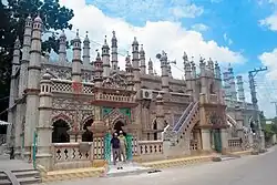
 Chini Mosque, Saidpur | |
.svg.png.webp) | |
| Coordinates: 25°46.7′N 88°53.5′E / 25.7783°N 88.8917°E | |
| Country | |
| Division | Rangpur |
| District | Nilphamari |
| Headquarters | Saidpur |
| Area | |
| • Upazila | 121.66 km2 (46.97 sq mi) |
| • Urban | 34.82 km2 (13.44 sq mi) |
| [1] | |
| Elevation | 36 m (118 ft) |
| Population (2011) | |
| • Upazila | 264,461 |
| • Density | 2,200/km2 (5,600/sq mi) |
| Time zone | UTC+6 (BST) |
| Postal code | 5310 |
| Website | Syedpur Upazila |
Saidpur (Bengali: সৈয়দপুর) is an upazila of Nilphamari District in the Division of Rangpur, Bangladesh. Saidpur thana, later turned into an upazila, was established in 1915.[1]
Geography
Saidpur is located at 25°46′40″N 88°53′30″E / 25.7778°N 88.8917°E. The upazila is bounded by Nilphamari Sadar and Kishoreganj upazilas on the north, Badarganj and Parbatipur upazilas on the south, Taraganj upazila on the east, Chirirbandar and Khansama upazilas on the west. Total area of Saidpur is 121.66 km2.
Demographics
According to the 2011 Bangladesh census, Saidpur Upazila had 58,137 households and a population of 264,461. 58,868 (22.26%) were under 10 years of age. Saidpur had a literacy rate (age 7 and over) of 54.56%, compared to the national average of 51.8%, and a sex ratio of 977 females per 1000 males. 130,041 (49.17%) lived in urban areas.[3][4]
As of the 1991 Bangladesh census, Saidpur has a population of 199422. Males constitute 52.19% of the population, and females 47.81%. This Upazila's eighteen up population is 98745. Saidpur has an average literacy rate of 38.7% (7+ years), and the national average of 32.4% literate.[5]
Points of interest
- Saidpur Airport
- Syedpur Railway Workshop
- Chini Mosque (established 1863)[6]
- Martuza Institute (established 1882)[6]
- Al Jamiatul Islamia Darul-Ulam Madrasa (established 1945)[6]
Administration
Saidpur Upazila is divided into 1 municipality (Saidpur Municipality) and six union parishads: Bangalipur, Botlagari, Kamarpukur, Kasirambelpukur, Khatamadhupur, and Saidpur Cantonment. The union parishads are subdivided into 42 mauzas and 39 villages.[3]
Saidpur Municipality is subdivided into 15 wards and 43 mahallas.[3]
See also
References
- 1 2 "Municipality at a glance - Syedpur Upazila". Bangladesh National Portal (in Bengali). December 2020. Retrieved 1 January 2021.
- ↑ "Elevation of Saidpur,Bangladesh Elevation Map, Topography, Contour". Retrieved 1 January 2021.
- 1 2 3 4 "Bangladesh Population and Housing Census 2011 Zila Report – Nilphamari" (PDF). bbs.gov.bd. Bangladesh Bureau of Statistics.
- ↑ "Community Tables: Nilphamari district" (PDF). bbs.gov.bd. Bangladesh Bureau of Statistics. 2011.
- ↑ "Population Census Wing, BBS". Archived from the original on 2005-03-27. Retrieved November 10, 2006.
- 1 2 3 Abdus Sattar (2012), "Saidpur Upazila", in Sirajul Islam and Ahmed A. Jamal (ed.), Banglapedia: National Encyclopedia of Bangladesh (Second ed.), Asiatic Society of Bangladesh
