| Rokan River Sungai Rokan, Soengai Rekan | |
|---|---|
 Map of the Rokan (left) and Indragiri rivers by Isaak de Graaf, circa 1690-1743. | |
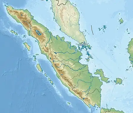 Location of river mouth  Rokan River (Indonesia) | |
| Location | |
| Country | Indonesia |
| Province | Riau |
| Physical characteristics | |
| Source | |
| • location | Barisan Mountains |
| Mouth | |
• location | Malacca Strait |
| Length | 350 km (220 mi) |
| Basin size | 19,258 km2 (7,436 sq mi)[1] |
| Discharge | |
| • location | Rokan Delta, Bagansiapiapi, Malacca Strait |
| • average | (Period of data: 2009–2013)1,506 m3/s (53,200 cu ft/s)[1] |
| Basin features | |
| Tributaries | |
| • left | Rokan-kanan River |
| • right | Rokan-kiri River |
Rokan River is a river in Riau province, central-eastern Sumatra, Indonesia, about 1,100 km northwest of the capital Jakarta.[2][3]
Hydrology
The river originates in the Barisan Mountains in the west, and drains northeast-ward along Rokan Hulu Regency and Rokan Hilir Regency with estuarine located near the port town of Bagansiapiapi draining the water to Malacca Strait.
Tributaries include the Rokan-kiri River, Rokan-kanan River, Kumu River.
Geography
The river flows in the central area of Sumatra with predominantly tropical rainforest climate (designated as Af in the Köppen-Geiger climate classification).[4] The annual average temperature in the area is 23 °C. The warmest month is March, when the average temperature is around 24 °C, and the coldest is January, at 22 °C.[5] The average annual rainfall is 3766 mm. The wettest month is November, with an average of 336 mm rainfall, and the driest is July, with 113 mm rainfall.[6]
See also
References
- ↑ Rand McNally, The New International Atlas, 1993.
- ↑ Sungai Rokan at Geonames.org (cc-by); Last updated 2013-06-04; Database dump downloaded 2015-11-27
- ↑ Peel, M C; Finlayson, B L; McMahon, T A (2007). "Updated world map of the Köppen-Geiger climate classification". Hydrology and Earth System Sciences. 11 (5): 1633–1644. Bibcode:2007HESS...11.1633P. doi:10.5194/hess-11-1633-2007. Retrieved 30 January 2016.
- ↑ "NASA Earth Observations Data Set Index". NASA. 30 January 2016.
- ↑ "NASA Earth Observations: Rainfall (1 month - TRMM)". NASA/Tropical Rainfall Monitoring Mission. 30 January 2016.