Saddle, Arkansas | |
|---|---|
 Saddle  Saddle | |
| Coordinates: 36°21′18″N 91°38′20″W / 36.35500°N 91.63889°W | |
| Country | United States |
| State | Arkansas |
| County | Fulton |
| Elevation | 486 ft (148 m) |
| Time zone | UTC-6 (Central (CST)) |
| • Summer (DST) | UTC-5 (CDT) |
| Area code | 870 |
| GNIS feature ID | 58564[1] |
Saddle is an unincorporated community in eastern Fulton County, Arkansas, United States.[1] Saddle is located along Arkansas Highway 289, 10.3 miles (16.6 km) east of Salem.[2] The community is on the banks of South Fork Spring River.[3]
References
- 1 2 3 "Saddle". Geographic Names Information System. United States Geological Survey, United States Department of the Interior.
- ↑ Fulton County, Arkansas General Highway Map (PDF) (Map). Arkansas State Highway and Transportation Department. 2003. Retrieved December 4, 2012.
- ↑ Arkansas Atlas and Gazetteer, DeLorme, 2nd edition 2002, page = 27 ISBN 0-89933-345-1
Municipalities and communities of Fulton County, Arkansas, United States | ||
|---|---|---|
| Cities | 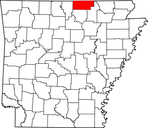 Map of Arkansas highlighting Fulton County | |
| Town | ||
| Unincorporated communities | ||
| Footnotes | ‡This populated place also has portions in an adjacent county or counties | |
This article is issued from Wikipedia. The text is licensed under Creative Commons - Attribution - Sharealike. Additional terms may apply for the media files.