Saint-Hilaire-de-Brethmas | |
|---|---|
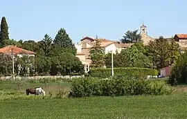 A general view of Saint-Hilaire-de-Brethmas | |
.svg.png.webp) Coat of arms | |
Location of Saint-Hilaire-de-Brethmas | |
 Saint-Hilaire-de-Brethmas  Saint-Hilaire-de-Brethmas | |
| Coordinates: 44°04′54″N 4°07′33″E / 44.0817°N 4.1258°E | |
| Country | France |
| Region | Occitania |
| Department | Gard |
| Arrondissement | Alès |
| Canton | Alès-3 |
| Intercommunality | Alès Agglomération |
| Government | |
| • Mayor (2020–2026) | Jean-Michel Perret[1] |
| Area 1 | 13.91 km2 (5.37 sq mi) |
| Population | 4,616 |
| • Density | 330/km2 (860/sq mi) |
| Time zone | UTC+01:00 (CET) |
| • Summer (DST) | UTC+02:00 (CEST) |
| INSEE/Postal code | 30259 /30560 |
| Elevation | 107–202 m (351–663 ft) (avg. 116 m or 381 ft) |
| 1 French Land Register data, which excludes lakes, ponds, glaciers > 1 km2 (0.386 sq mi or 247 acres) and river estuaries. | |
Saint-Hilaire-de-Brethmas (French pronunciation: [sɛ̃.t‿ilɛʁ də bʁɛtmas]; Occitan: Sent Alari de Bretmàs) is a commune in the Gard department in southern France.
Population
|
| ||||||||||||||||||||||||||||||||||||||||||||||||||||||
| Source: EHESS[3] and INSEE (1968-2017)[4] | |||||||||||||||||||||||||||||||||||||||||||||||||||||||
See also
References
- ↑ "Répertoire national des élus: les maires" (in French). data.gouv.fr, Plateforme ouverte des données publiques françaises. 4 May 2022.
- ↑ "Populations légales 2021". The National Institute of Statistics and Economic Studies. 28 December 2023.
- ↑ Des villages de Cassini aux communes d'aujourd'hui: Commune data sheet Saint-Hilaire-de-Brethmas, EHESS (in French).
- ↑ Population en historique depuis 1968, INSEE
External links
Wikimedia Commons has media related to Saint-Hilaire-de-Brethmas.
This article is issued from Wikipedia. The text is licensed under Creative Commons - Attribution - Sharealike. Additional terms may apply for the media files.