Saint-Marcel-l'Éclairé | |
|---|---|
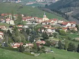 Saint-Marcel-l'Éclairé in 2017. | |
.svg.png.webp) Coat of arms | |
Location of Saint-Marcel-l'Éclairé | |
 Saint-Marcel-l'Éclairé  Saint-Marcel-l'Éclairé | |
| Coordinates: 45°52′33″N 4°26′06″E / 45.8758°N 4.435°E | |
| Country | France |
| Region | Auvergne-Rhône-Alpes |
| Department | Rhône |
| Arrondissement | Villefranche-sur-Saône |
| Canton | Tarare |
| Intercommunality | CA de l'Ouest Rhodanien |
| Government | |
| • Mayor (2020–2026) | Hervé Digas[1] |
| Area 1 | 11.88 km2 (4.59 sq mi) |
| Population | 543 |
| • Density | 46/km2 (120/sq mi) |
| Time zone | UTC+01:00 (CET) |
| • Summer (DST) | UTC+02:00 (CEST) |
| INSEE/Postal code | 69225 /69170 |
| Elevation | 360–843 m (1,181–2,766 ft) |
| 1 French Land Register data, which excludes lakes, ponds, glaciers > 1 km2 (0.386 sq mi or 247 acres) and river estuaries. | |
Saint-Marcel-l'Éclairé (French pronunciation: [sɛ̃ maʁsɛl leklɛʁe] ⓘ) is a commune in the Rhône department in eastern France.
See also
References
- ↑ "Répertoire national des élus: les maires". data.gouv.fr, Plateforme ouverte des données publiques françaises (in French). 2 December 2020.
- ↑ "Populations légales 2021". The National Institute of Statistics and Economic Studies. 28 December 2023.
Wikimedia Commons has media related to Saint-Marcel-l'Éclairé.
This article is issued from Wikipedia. The text is licensed under Creative Commons - Attribution - Sharealike. Additional terms may apply for the media files.