Highway 48 | ||||
|---|---|---|---|---|
| Route information | ||||
| Maintained by Ministry of Highways and Infrastructure | ||||
| Length | 237.8 km[1] (147.8 mi) | |||
| Existed | 1976–present | |||
| Major junctions | ||||
| West end | ||||
| East end | ||||
| Location | ||||
| Country | Canada | |||
| Province | Saskatchewan | |||
| Rural municipalities | Edenwold, South Qu'Appelle, Lajord, Francis, Montmartre, Chester, Kingsley, Hazelwood, Wawken, Walpole, Maryfield | |||
| Highway system | ||||
|
| ||||
| ||||

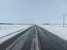
Highway 48 west of Fairlight
| Communities |
|---|
Highway 48 is a provincial highway in the Canadian province of Saskatchewan. It runs from Highway 1 at White City, about 10 kilometres (6.2 mi) east of Regina, to the Manitoba — Saskatchewan border, where it becomes Provincial Road 257. Highway 48 is about 238 kilometres (148 mi) long.[1]
This highway was known as Highway 16 until 1976. It was renumbered as Highway 48 when the Yellowhead Highway was designated as Highway 16 throughout the province.
The original Highway 48 was located in south-western Saskatchewan, travelling from the Willow Creek Border Crossing to Highway 13 at Govenlock.[2] The route was renumbered to Highway 348 in the 1960s[3] before becoming part of Highway 21 in the 1970s.[4]
Major intersections
Form west to east:
| Rural municipality | Location | km[1] | mi | Destinations | Notes | |||
|---|---|---|---|---|---|---|---|---|
| Edenwold No. 158 | White City | 0.0 | 0.0 | Interchange; Hwy 1 exit 217 | ||||
| | 7.7 | 4.8 | ||||||
| South Qu'Appelle No. 157 | | 16.3 | 10.1 | |||||
| Lajord No. 128 | Davin | 22.3 | 13.9 | West end of Hwy 620 concurrency | ||||
| Francis No. 127 | | 29.5 | 18.3 | East end of Hwy 620 concurrency | ||||
| Vibank | 34.0 | 21.1 | centre | |||||
| | 40.3 | 25.0 | ||||||
| Odessa | 46.3 | 28.8 | centre | |||||
| Montmartre No. 126 | Kendal | 59.5 | 37.0 | |||||
| Montmartre | 71.7 | 44.6 | West end of Hwy 606 concurrency | |||||
| 72.5 | 45.0 | East end of Hwy 606 concurrency | ||||||
| | 84.7 | 52.6 | West of Candiac; west end of Hwy 617 concurrency | |||||
| Glenavon | 94.3 | 58.6 | East end of Hwy 617 concurrency | |||||
| Chester No. 125 | | 103.4 | 64.2 | |||||
| Peebles | 110.4 | 68.6 | West end of Hwy 616 concurrency | |||||
| | 115.9 | 72.0 | West of Windthorst; east end of Hwy 616 concurrency | |||||
| Kingsley No. 124 | Kipling | 135.7 | 84.3 | |||||
| Hazelwood No. 94 |
No major junctions | |||||||
| Wawken No. 93 | | 161.1 | 100.1 | East of Kennedy; Hwy 48 branches south; west end of Hwy 9 concurrency | ||||
| | 171.1 | 106.3 | ||||||
| | 174.4 | 108.4 | Hwy 48 branches east; east end of Hwy 9 concurrency | |||||
| Wawota | 192.3 | 119.5 | ||||||
| Walpole No. 92 | | 201.7 | 125.3 | West end of Hwy 601 concurrency | ||||
| | 202.5 | 125.8 | East end of Hwy 601 concurrency | |||||
| Maryfield No. 91 | Fairlight | 219.0 | 136.1 | |||||
| Maryfield | 229.5 | 142.6 | ||||||
| | 237.8 | 147.8 | Continuation into Manitoba | |||||
1.000 mi = 1.609 km; 1.000 km = 0.621 mi
| ||||||||
See also
References
- 1 2 3 Google (15 February 2018). "Highway 48 in Saskatchewan" (Map). Google Maps. Google. Retrieved 15 February 2018.
- ↑ The H.M. Gousha Company (1951). "Saskatchewan & Manitoba" (Map). Shell Highway Map of Western United States. The Shell Oil Company.
- ↑ Department of Highways and Transportation (1972). Saskatchewan Official Highway Map (Map). Queen's Printer.
- ↑ Saskatchewan Department of Highways and Transportation (1980). Official Highway Map (Map). Queen's Printer.
This article is issued from Wikipedia. The text is licensed under Creative Commons - Attribution - Sharealike. Additional terms may apply for the media files.
.svg.png.webp)