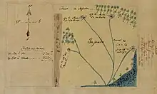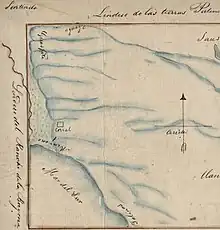
Rancho Sausal Redondo (Round Willow-grove Ranch) was a 22,458-acre (91 km2) Mexican land grant in present day Los Angeles County, California given in 1837 to Antonio Ygnacio Ávila by Juan Alvarado Governor of Alta California.[1] Rancho Sausal Redondo covered the area that now includes Playa Del Rey, El Segundo, Manhattan Beach, Lawndale, Hermosa Beach, Inglewood, Hawthorne, and Redondo Beach.[2][3]
History

Antonio Ygnacio Ávila (1781–1858), a member of the Ávila family of California, married Rosa Maria Ruiz (1789–1866) in 1804.
In 1822, Antonio Ygnacio Ávila was granted a permit from the new Mexican government to utilize grazing land totaling approximately 25,000 acres on what was to become Rancho Sausal Redondo. Ávila received a land grant of Rancho Sausal Redondo for most of this land from Governor Juan Alverado on May 20, 1837.[4]
With the cession of California to the United States following the Mexican–American War, the 1848 Treaty of Guadalupe Hidalgo provided that the land grants would be honored. As required by the Land Act of 1851, a claim for Rancho Sausal Redondo was filed with the Public Land Commission in 1852,[5][6] and the grant was patented to Antonio Ygnacio Ávila in 1855.[7]
Antonio Ygnacio Ávila died in 1858, and in 1868 Ávila's heirs were forced to sell the rancho to pay the probate costs. The Rancho was sold to Sir Robert Burnett (11th. Baronet, 1876–1894) who used the land for sheep and cattle raising. Having previously acquired Rancho Aguaje de la Centinela, Burnett combined the total area into the Centinela Ranch, thus reuniting the major area of the original land grant. Clear title to the land did not occur until 1873, when a U.S. District Court upheld Burnett's purchase against a suit filed by Ávila heir Tomas Avila Sanchez.
In 1873, Robert Burnett leased the land to Daniel Freeman and returned to his native Scotland. Freeman moved to the ranch with his family, increased the stock, and planted citrus trees. When the 1875 drought ruined the livestock industry, Freeman turned to dry farming. In 1885, Freeman purchased the remainder of Rancho Sausal Redondo. Daniel Freeman was the last person to own all of Rancho Sausal Redondo.[8][9][10]
Historic sites of the Rancho
- Centinela Adobe – Burnett's adobe ranch house in Inglewood.[11]
See also
References
- ↑ Ogden Hoffman, 1862, Reports of Land Cases Determined in the United States District Court for the Northern District of California, Numa Hubert, San Francisco
- ↑ Map of Rancho Sausal Redondo
- ↑ Map of old Spanish and Mexican ranchos in Los Angeles County
- ↑ Bruce L. Megowan, Maureen D. Megowan, Historic Tales from Palos Verdes and the South Bay, The History Press, Charleston, SC, Jul 1, 2014, p.103
- ↑ United States. District Court (California : Southern District) Land Case 354 SD
- ↑ Finding Aid to the Documents Pertaining to the Adjudication of Private Land Claims in California, circa 1852-1892
- ↑ Report of the Surveyor General 1844–1886 Archived 2009-05-04 at the Wayback Machine
- ↑ Family History, Freeman Family Papers
- ↑ Daniel Freeman Family Papers
- ↑ James Osborne, 2006, Lawndale, Arcadia Publishing,ISBN 0-7385-3079-4
- ↑ History of Lawndale
External links
- Diseño del Rancho Sausal Redondo : Calif. fromcontent.cdlib.org California Digital Library, Contributing Institution: UC Berkeley, Bancroft Library
- Plat of the Rancho Sausal Redondo, 1868 from hdl.huntington.org, Huntington Digital Library
- Map of old Spanish and Mexican ranchos in Los Angeles County
