| Scottish Gaelic name | Sgalpaigh (an t-Sratha) |
|---|---|
| Pronunciation | [ˈs̪kal̪ˠpaj] ⓘ |
| Old Norse name | Skalprøy[1] |
| Meaning of name | ship island[2] |
| Location | |
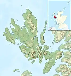
 Scalpay Scalpay shown relative to Skye | |
| OS grid reference | NG605315 |
| Coordinates | 57°19′N 5°59′W / 57.31°N 5.98°W |
| Physical geography | |
| Island group | Skye |
| Area | 2,483 ha (9+5⁄8 sq mi)[1] |
| Area rank | 32 [3] |
| Highest elevation | Mullach na Càrn, 396 m (1,299 ft) |
| Administration | |
| Sovereign state | United Kingdom |
| Country | Scotland |
| Council area | Highland |
| Demographics | |
| Population | 4[4] |
| Population rank | 77= [3] |
| Population density | 0.16/km2 (0.41/sq mi)[1][4] |
| References | [5] |
Scalpay (/ˈskælpeɪ/;[6] Scottish Gaelic: Sgalpaigh) is an inhabited island in the Inner Hebrides of Scotland which has a population of 4.
Geology
The bedrock of Scalpay is largely the Neoproterozoic age sandstone and conglomerates of the Sithean Glac an Ime Member of the Applecross Formation and in the west, the Mullach nan Carn members of the Diabaig Formation, a unit of the Torridon Group, or informally the Torridonian sandstone. Outcrops of hornfelsed basalt of the Palaeocene age Skye Lava Group and the Palaeogene age Scalpay granite are found in the south and west of Scalpay. The Scalpay Sandstone and Pabay Shale formations found in the southeast of the island around Scalpay House are assigned to the Lias Group. The Staffin Shale and Staffin Bay formations are of late Jurassic age and found east of Rubha Aosail Sligneach at Caolas Scalpay. Quaternary deposits are represented by peat in the north, present day marine deposits and raised marine deposits along the southwestern shore and a restricted area of glacial till in the interior. [7][8]
Geography
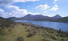
Separated from the east coast of Skye by Loch na Cairidh, Scalpay rises to 396 metres (1,299 ft) at Mullach na Càrn. It has an area of just under 25 square kilometres (9+1⁄2 sq mi). The island had a population of ten usual residents in 2001[9] and of four in 2011.[4]
Scalpay is privately owned and operates a red deer farm, shooting estate and holiday cottages. Much of Scalpay is covered with heather, while other areas are conifer forestry plantations.
Etymology
Mac an Tàilleir (2003) suggests the name derives from "ship island" from the Norse.[2] However, Haswell-Smith states that the Old Norse name was Skalprøy, meaning "scallop island".[1]
Prehistory and Archaeology
Between 1999 and 2004 a large scale archaeological project, Scotland's First Settlers, was undertaken in the Inner Sound to locate and examine sites relating to the Mesolithic period in the strait. The entire coastline of the Inner Sound together with its islands was walked by volunteers and archaeologists. On Scalpay they found 9 lithic scatters. All of these sites were prehistoric but only three of the sites contained microliths, which confirms them as Mesolithic.[10]
History

Dean Monro gave the following description of Scalpay in 1549:
...a fair hunting forest, full of deer, with certain little woods and small towns, well inhabited and manured, with many strong coves, good for fishing, in heritage it pertains to Maclean of Duart.[11]
By the time of Dr Johnson's tour, the island was held by a tenant of Sir Alexander Macdonald.[12]
Shipping magnate and politician, Donald Currie owned the island in the late 19th century and was responsible for the construction of the first roads and much tree planting.
See also
Footnotes
- 1 2 3 4 Haswell-Smith (2004) p. 153
- 1 2 Mac an Tàilleir (2003) p. 103
- 1 2 Area and population ranks: there are c. 300 islands over 20 ha in extent and 93 permanently inhabited islands were listed in the 2011 census.
- 1 2 3 National Records of Scotland (15 August 2013). "Appendix 2: Population and households on Scotland's Inhabited Islands" (PDF). Statistical Bulletin: 2011 Census: First Results on Population and Household Estimates for Scotland Release 1C (Part Two) (PDF) (Report). SG/2013/126. Retrieved 14 August 2020.
- ↑ Ordnance Survey: Landranger map sheet 24 Raasay & Applecross (Loch Torridon & Plockton) (Map). Ordnance Survey. 2012. ISBN 9780319231104.
- ↑ Wells, John C. (2008). Longman Pronunciation Dictionary (3rd ed.). Longman. ISBN 978-1-4058-8118-0.
- ↑ "Onshore Geoindex". British Geological Survey. Retrieved 5 February 2020.
- ↑ "Scotland sheet 71W, Broadford, Solid and Drift Geology". BGS large map images. British Geological Survey. Retrieved 5 February 2020.
- ↑ General Register Office for Scotland (28 November 2003) Scotland's Census 2001 – Occasional Paper No 10: Statistics for Inhabited Islands. Retrieved 26 February 2012.
- ↑ "Vol 31 (2009): Mesolithic and later sites around the Inner Sound, Scotland the work of the Scotland's First Settlers project 1998-2004 | Scottish Archaeological Internet Reports". journals.socantscot.org. Retrieved 15 August 2021.
- ↑ Monro (1549) pp. 26-27
- ↑ Johnson (1795) p. 246
References
- Haswell-Smith, Hamish (2004). The Scottish Islands. Edinburgh: Canongate. ISBN 978-1-84195-454-7.
- Johnson, Samuel A Journey to the Western Islands of Scotland. London. Strachan and Cadell, 1785 (new edition).
- Mac an Tàilleir, Iain (2003) Ainmean-àite/Placenames. (pdf) Pàrlamaid na h-Alba. Retrieved 26 August 2012.
- Monro, Sir Donald (1549) Description of the Western Isles of Scotland. William Auld. Edinburgh - 1774 edition.
