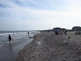
| Scarborough State Beaches | |
|---|---|
 | |
 Location in Rhode Island | |
| Location | Narragansett, Rhode Island, United States |
| Coordinates | 41°23′23″N 71°28′23″W / 41.38972°N 71.47306°W[1] |
| Area | 60 acres (24 ha)[2] |
| Elevation | 10 ft (3.0 m)[1] |
| Established | 1937 |
| Administrator | Rhode Island Department of Environmental Management Division of Parks & Recreation |
| Website | Scarborough North State Beach |
.jpg.webp)
Historic postcard image of Scarborough Beach
Scarborough State Beach is a public recreation area fronting the Atlantic Ocean in the town of Narragansett, Rhode Island. The state park occupies 60 acres (24 ha) comprising two units located at 870 and 970 Ocean Road. The beach offers saltwater bathing, picnicking, observation tower, and boardwalk and is open seasonally.[3][4]
History
The beach was first developed with a pavilion in 1937. The two-unit complex was created with the addition of a southern component when the state purchased 7-acre Lido's Beach in 1981 and 9-acre Olivo's Beach in 1986.[5] Extensive renovations were completed in 1987.[2]
References
- 1 2 "Scarborough State Beach". Geographic Names Information System. United States Geological Survey, United States Department of the Interior.
- 1 2 "Scarborough North & South State Beach Complex History". Rhode Island Department of Environmental Management. Retrieved February 1, 2023.
- ↑ "Scarborough North State Beach". Rhode Island Department of Environmental Management. Retrieved February 1, 2023.
- ↑ "Rhode Island State Beaches: Parking Passes". Rhode Island Department of Environmental Management. Retrieved February 1, 2023.
- ↑ "Land Acquisition/RI Dept. Environmental Management" (PDF). Rhode Island Department of Environmental Management. Retrieved January 12, 2018.
External links
- Scarborough North State Beach Rhode Island Department of Environmental Management Division of Parks & Recreation
This article is issued from Wikipedia. The text is licensed under Creative Commons - Attribution - Sharealike. Additional terms may apply for the media files.