| Seward Mountain | |
|---|---|
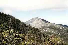 Seward Mt. seen from Seymour Mt. | |
| Highest point | |
| Elevation | 4,347 feet (1,325 m)[1] |
| Prominence | 2,030 ft (620 m)[2] |
| Listing | |
| Coordinates | 44°9.58′N 74°11.98′W / 44.15967°N 74.19967°W |
| Geography | |
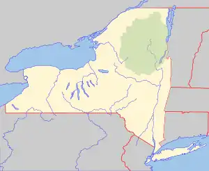 Seward Mountain Location of Seward Mountain within New York  Seward Mountain Seward Mountain (the United States) | |
| Location | Franklin County, New York |
| Parent range | Seward Mountains |
| Topo map | USGS Ampersand Lake |
| Climbing | |
| First ascent | 1870, Verplanck Colvin and Alvah Dunning[3] |
Seward Mountain is a mountain located in Franklin County, New York, of which it is the highest point. Seward Mtn. is named after William H. Seward (1801–1872), Governor of New York (1839–1842), and United States Secretary of State (1861–1869). The mountain is part of the Seward Mountains of the Adirondacks. Seward Mountain is flanked to the southwest by Donaldson Mountain, and to the east faces Seymour Mountain across Ouluska Pass.
Seward Mountain stands within the watershed of the Raquette River, which drains into the Saint Lawrence River in Canada, and into the Gulf of Saint Lawrence. The southeast slopes of Seward Mtn. drain into Seward Brook, thence into the Cold River, a tributary of the Raquette River. The west end of Seward Mtn. drains into Calkins Brook, thence into the Raquette River. The northern slopes of Seward drain into Ward Brook, thence into Ampersand Lake, Ampersand Brook, Stony Creek, and the Raquette River.
Seward Mountain is within the High Peaks Wilderness Area of New York's Adirondack Park.
Climate
| Climate data for Seward Mountain 44.1603 N, 74.2017 W, Elevation: 4,029 ft (1,228 m) (1991–2020 normals) | |||||||||||||
|---|---|---|---|---|---|---|---|---|---|---|---|---|---|
| Month | Jan | Feb | Mar | Apr | May | Jun | Jul | Aug | Sep | Oct | Nov | Dec | Year |
| Mean daily maximum °F (°C) | 20.0 (−6.7) |
22.2 (−5.4) |
29.6 (−1.3) |
44.3 (6.8) |
56.9 (13.8) |
65.3 (18.5) |
69.3 (20.7) |
68.0 (20.0) |
62.4 (16.9) |
49.7 (9.8) |
35.2 (1.8) |
25.5 (−3.6) |
45.7 (7.6) |
| Daily mean °F (°C) | 11.4 (−11.4) |
13.2 (−10.4) |
20.9 (−6.2) |
34.3 (1.3) |
47.0 (8.3) |
56.1 (13.4) |
60.5 (15.8) |
59.2 (15.1) |
53.0 (11.7) |
40.9 (4.9) |
28.0 (−2.2) |
18.0 (−7.8) |
36.9 (2.7) |
| Mean daily minimum °F (°C) | 2.8 (−16.2) |
4.2 (−15.4) |
12.2 (−11.0) |
24.2 (−4.3) |
37.1 (2.8) |
46.8 (8.2) |
51.8 (11.0) |
50.4 (10.2) |
43.7 (6.5) |
32.1 (0.1) |
20.8 (−6.2) |
10.5 (−11.9) |
28.1 (−2.2) |
| Average precipitation inches (mm) | 4.39 (112) |
3.27 (83) |
3.97 (101) |
4.98 (126) |
5.29 (134) |
6.28 (160) |
6.00 (152) |
5.73 (146) |
5.36 (136) |
6.19 (157) |
4.85 (123) |
4.69 (119) |
61 (1,549) |
| Source: PRISM Climate Group[4] | |||||||||||||
See also
Notes
- ↑ Summit elevation between 1,320 and 1,330 m.
- ↑ Key col elevation is 704.4 m.
- ↑ Terrie, Phillip G., Contested Terrain; A New History of Nature and People in the Adirondacks, Syracuse: Adirondack Museum/Syracuse University Press, 1997. ISBN 978-0-8156-0904-9.
- ↑ "PRISM Climate Group, Oregon State University". PRISM Climate Group, Oregon State University. Retrieved October 26, 2023.
To find the table data on the PRISM website, start by clicking Coordinates (under Location); copy Latitude and Longitude figures from top of table; click Zoom to location; click Precipitation, Minimum temp, Mean temp, Maximum temp; click 30-year normals, 1991-2020; click 800m; click Retrieve Time Series button.
External links
- Peakbagger.com: Seward Mountain
- Summitpost.org: Seward Mountain
- U.S. Geological Survey Geographic Names Information System: Seward Mountain