Staré Hutě | |
|---|---|
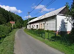 Main street | |
 Flag  Coat of arms | |
 Staré Hutě Location in the Czech Republic | |
| Coordinates: 49°7′45″N 17°16′40″E / 49.12917°N 17.27778°E | |
| Country | |
| Region | Zlín |
| District | Uherské Hradiště |
| First mentioned | 1665 |
| Area | |
| • Total | 7.34 km2 (2.83 sq mi) |
| Elevation | 393 m (1,289 ft) |
| Population (2023-01-01)[1] | |
| • Total | 119 |
| • Density | 16/km2 (42/sq mi) |
| Time zone | UTC+1 (CET) |
| • Summer (DST) | UTC+2 (CEST) |
| Postal code | 686 01 |
| Website | www |
Staré Hutě (German: Althütten) is a municipality and village in Uherské Hradiště District in the Zlín Region of the Czech Republic. It has about 100 inhabitants.
Staré Hutě lies approximately 16 kilometres (10 mi) north-west of Uherské Hradiště, 31 km (19 mi) west of Zlín, and 232 km (144 mi) south-east of Prague.
Gallery
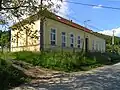 Old school
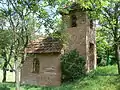 Chapel of the Virgin Mary
References
Wikimedia Commons has media related to Staré Hutě.
This article is issued from Wikipedia. The text is licensed under Creative Commons - Attribution - Sharealike. Additional terms may apply for the media files.