Topolná | |
|---|---|
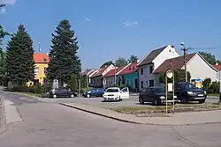 Centre of Topolná | |
 Flag  Coat of arms | |
 Topolná Location in the Czech Republic | |
| Coordinates: 49°7′19″N 17°32′40″E / 49.12194°N 17.54444°E | |
| Country | |
| Region | Zlín |
| District | Uherské Hradiště |
| First mentioned | 1318 |
| Area | |
| • Total | 10.39 km2 (4.01 sq mi) |
| Elevation | 192 m (630 ft) |
| Population (2023-01-01)[1] | |
| • Total | 1,614 |
| • Density | 160/km2 (400/sq mi) |
| Time zone | UTC+1 (CET) |
| • Summer (DST) | UTC+2 (CEST) |
| Postal code | 687 11 |
| Website | www |
Topolná is a municipality and village in Uherské Hradiště District in the Zlín Region of the Czech Republic. It has about 1,600 inhabitants.
Topolná lies approximately 10 kilometres (6 mi) north-east of Uherské Hradiště, 15 km (9 mi) south-west of Zlín, and 250 km (160 mi) south-east of Prague.
In Topolná there is the central longwave broadcasting facility of the Czech Republic, Topolná transmitter.
References
Wikimedia Commons has media related to Topolná.
This article is issued from Wikipedia. The text is licensed under Creative Commons - Attribution - Sharealike. Additional terms may apply for the media files.