State Hill, Pennsylvania | |
|---|---|
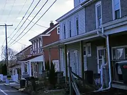
 A view of homes in State Hill | |
 State Hill Location in Pennsylvania and the United States  State Hill State Hill (the United States) | |
| Coordinates: 40°21′45″N 76°01′50″W / 40.36250°N 76.03056°W | |
| Country | United States |
| State | Pennsylvania |
| County | Berks |
| Township | Lower Heidelberg |
| Time zone | UTC-5 (EST) |
| • Summer (DST) | UTC-4 (EDT) |
| Zip Code | 19608 |
State Hill is an unincorporated community that is located in Lower Heidelberg Township, Pennsylvania in Berks County, Pennsylvania.
History
The area that is now State Hill was once called Lorah. This was named for the first settler within the village's boundary. At one time, the main road through the unincorporated community was called Dry Road. It received the name for lack of water to tap into for wells. This road is now known as Brownsville Road.
The village started out as just a few cabins, but by the mid-1800s had built a tavern. It was called Dry Tavern, named after the road on which it was located. Current residents have a view of Blue Marsh Lake from Brownsville Road.
The village is also home to a now-defunct elementary school, the Lower Heidelberg Consolidated School, which operated from 1931 to 2006. It is served by the Wilson School District.
State Hill also has several businesses, including Berks Western Telecom, Ganly's Pub and Deli, Blue Marsh Taxidermy, a Western Berks Fire Department station, and the Lower Heidelberg Township Police and Municipal building. Ganly's was built in 1993, near where The Beer Garden Tavern used to be located.
