Thrumster | |
|---|---|
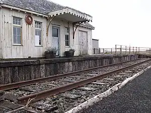
 Outside shot of Thrumster station | |
| General information | |
| Location | Thrumster, Highland Scotland |
| Platforms | 1 |
| Other information | |
| Status | Disused |
| History | |
| Opened | 1 July 1903[1] |
| Closed | 3 April 1944[1] |
| Original company | Wick and Lybster Railway |
| Pre-grouping | Wick and Lybster Railway operated by Highland Railway |
| Post-grouping | LMS |
Thrumster was a railway station located at Thrumster, Highland, Scotland between Wick and Lybster. The station building can still be seen alongside the main road in Thrumster.
History
Latitude: 58° 23' 23.82" N Longitude: -3° 08' 10.75" W
The station was opened as part of the Wick and Lybster Railway on 1 July 1903. It was one of the five stations along the line.[1][2] The Railway was shown in Schedule one of the RailwayAct 1921 as being part of part of The North Western, Midland, and West Scottish Group. [3]
As with the other stations on the line, the station was closed from 3 April 1944. It began to be used as a post office [1][4]
In 2011 Yarrows Heritage Trust restored the railway.[5]
| Preceding station | Disused railways | Following station | ||
|---|---|---|---|---|
| Welsh's Crossing Halt Station and Line closed |
Highland Railway Wick and Lybster Light Railway |
Wick Station open; Line closed |
References
Notes
- 1 2 3 4 Butt (1995), p. 229
- ↑ "Railway station". Yarrowsheritagetrust. Retrieved 29 January 2023.
- ↑ "Railways Act 1921".
- ↑ Quick, M. E. (2002). Railway passenger stations in England, Scotland and Wales – a chronology. Richmond: Railway and Canal Historical Society. p. 421. OCLC 931112387.
- ↑ "Railway station". Yarrowsheritagetrust. Retrieved 29 January 2023.
Sources
- Butt, R. V. J. (October 1995). The Directory of Railway Stations: details every public and private passenger station, halt, platform and stopping place, past and present (1st ed.). Sparkford: Patrick Stephens Ltd. ISBN 978-1-85260-508-7. OCLC 60251199. OL 11956311M.
- Jowett, Alan (March 1989). Jowett's Railway Atlas of Great Britain and Ireland: From Pre-Grouping to the Present Day (1st ed.). Sparkford: Patrick Stephens Ltd. ISBN 978-1-85260-086-0. OCLC 22311137.
- Jowett, Alan (2000). Jowett's Nationalised Railway Atlas (1st ed.). Penryn, Cornwall: Atlantic Transport Publishers. ISBN 978-0-906899-99-1. OCLC 228266687.
58°23′24″N 3°08′10″W / 58.3901°N 3.1362°W
This article is issued from Wikipedia. The text is licensed under Creative Commons - Attribution - Sharealike. Additional terms may apply for the media files.