Trempealeau, Wisconsin | |
|---|---|
 Looking north at downtown Trempealeau | |
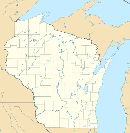
 Location of Trempealeau in Trempealeau County, Wisconsin. | |
 Trempealeau  Trempealeau | |
| Coordinates: 44°00′28″N 91°26′20″W / 44.00791°N 91.43887°W | |
| Country | |
| State | |
| County | Trempealeau |
| Area | |
| • Total | 2.25 sq mi (5.84 km2) |
| • Land | 1.99 sq mi (5.14 km2) |
| • Water | 0.27 sq mi (0.70 km2) |
| Elevation | 738 ft (225 m) |
| Population | |
| • Total | 1,843 |
| • Density | 928.5/sq mi (358.6/km2) |
| Time zone | UTC-6 (Central (CST)) |
| • Summer (DST) | UTC-5 (CDT) |
| Area code | 608 |
| FIPS code | 55-80475[4] |
| GNIS feature ID | 1575590[2] |
| Website | www |
Trempealeau (/ˈtʃrɛmpəloʊ/ TREM-pə-loh)[5] is a village located along the Mississippi River in Trempealeau County in the U.S. state of Wisconsin. The population was 1,843 at the 2020 census.[3] The village is surrounded by the Town of Trempealeau.
History
An ancient Native American site with earthwork mounds, also known as Trempealeau, has been studied near the village through archeological excavations in the 21st century. It is theorized as a possible mission site or colony of Cahokia, the major center of Mississippian culture from 1000CE to 1450CE located 500 miles to the south in present-day Illinois near St. Louis, Missouri.
Studies have been done through the Mississippi Valley Archaeology Center associated with the University of Wisconsin Madison. Archeologists Danielle Benden[6] and Robert “Ernie” Boszhardt said they have found some evidence of Mississippian settlement about 1050E.[7] The newcomers are believed to have introduced corn culture to the area.[7][6] The archeology site is slightly downriver of the prominent landmark, Trempealeau Mountain. In 2013 evidence was found of several former structures that exhibited characteristics of Mississippian style. There is some evidence that a religious group came here from Cahokia, perhaps fleeing persecution.[8]
European-American settlement did not take place here until the mid-19th century, although French and English fur traders interacted with Native Americans of the area from the colonial period and into the 19th century. A post office called Trempealeau was first established in 1852.[9] The village was named after a nearby island in the Mississippi River, that named by a French explorer.[10]
Geography
Trempealeau is located at 44°0′24″N 91°26′4″W / 44.00667°N 91.43444°W (44.006906, -91.434572).[11]
According to the United States Census Bureau, the village has a total area of 2.25 square miles (5.83 km2), of which, 1.99 square miles (5.15 km2) of it is land and 0.27 square miles (0.70 km2) is water.[12]
Demographics
| Census | Pop. | Note | %± |
|---|---|---|---|
| 1880 | 615 | — | |
| 1900 | 609 | — | |
| 1910 | 535 | −12.2% | |
| 1920 | 536 | 0.2% | |
| 1930 | 541 | 0.9% | |
| 1940 | 527 | −2.6% | |
| 1950 | 645 | 22.4% | |
| 1960 | 704 | 9.1% | |
| 1970 | 743 | 5.5% | |
| 1980 | 956 | 28.7% | |
| 1990 | 1,039 | 8.7% | |
| 2000 | 1,319 | 26.9% | |
| 2010 | 1,529 | 15.9% | |
| 2020 | 1,843 | 20.5% | |
| U.S. Decennial Census[13] | |||
2020 census
As of the census of 2020,[3] the population was 1,843. The population density was 928.5 inhabitants per square mile (358.5/km2). There were 921 housing units at an average density of 464.0 per square mile (179.2/km2). The racial makeup of the village was 94.0% White, 0.4% Asian, 0.3% Black or African American, 0.2% Native American, 0.5% from other races, and 4.6% from two or more races. Ethnically, the population was 2.0% Hispanic or Latino of any race.
According to the American Community Survey estimates for 2016-2020, the median income for a household in the village was $56,383, and the median income for a family was $67,500. Male full-time workers had a median income of $45,278 versus $32,344 for female workers. The per capita income for the village was $30,328. About 2.7% of families and 4.1% of the population were below the poverty line, including 6.4% of those under age 18 and 3.6% of those age 65 or over.[14] Of the population age 25 and over, 98.3% were high school graduates or higher and 20.8% had a bachelor's degree or higher.[15]
2010 census
As of the census[16] of 2010, there were 1,529 people, 704 households, and 426 families residing in the village. The population density was 817.6 inhabitants per square mile (315.7/km2). There were 835 housing units at an average density of 446.5 per square mile (172.4/km2). The racial makeup of the village was 97.8% White, 0.1% African American, 0.4% Native American, 0.4% Asian, 0.3% from other races, and 1.0% from two or more races. Hispanic or Latino of any race were 1.4% of the population.
There were 704 households, of which 27.3% had children under the age of 18 living with them, 47.7% were married couples living together, 8.2% had a female householder with no husband present, 4.5% had a male householder with no wife present, and 39.5% were non-families. 33.2% of all households were made up of individuals, and 13.6% had someone living alone who was 65 years of age or older. The average household size was 2.17 and the average family size was 2.74.
The median age in the village was 42.7 years. 20.9% of residents were under the age of 18; 6.4% were between the ages of 18 and 24; 26.7% were from 25 to 44; 28.8% were from 45 to 64; and 17.1% were 65 years of age or older. The gender makeup of the village was 49.8% male and 50.2% female.
Notable people
- Gideon Winans Allen, Wisconsin State Representative
- Robert Grimes Coman, U.S. Navy Commodore
- Charles Kenneth Leith, geologist
- Todd Auer, NFL Pro Football Player
Images
 Looking south at downtown Trempealeau, part of the Main Street Historic District, Mississippi River in background
 Looking west at the population sign along WIS 35
 Coman House, built in the 1860s in Trempealeau
 Melchoir House ruins on the outskirts of Trempealeau
 Building ruins on the outskirts of Trempealeau, southwest face
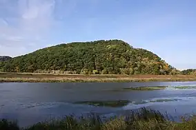
 Trempealeau Mountain at Perrot State Park
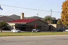
 Gale-Ettrick-Trempealeau High School in Galesville
See also
References
- ↑ "2019 U.S. Gazetteer Files". United States Census Bureau. Retrieved August 7, 2020.
- 1 2 "US Board on Geographic Names". United States Geological Survey. October 25, 2007. Retrieved January 31, 2008.
- 1 2 3 "2020 Decennial Census: Trempealeau village, Wisconsin". data.census.gov. U.S. Census Bureau. Retrieved August 5, 2022.
- ↑ "2010 ANSI Codes for Places, Wisconsin". census.gov. U.S. Census Bureau. Retrieved July 27, 2022.
- ↑ MissPronouncer.com: A HALFWAY DECENT AUDIO PRONUNCIATION GUIDE FOR WISCONSIN
- 1 2 David Tenenbaum, "Town meets gown to explore Wisconsin’s Trempealeau mounds", 23 July 2014, accessed 21 April 2015
- 1 2 une Patrick B. Anderson, "Trempealeau’s Big Dig: Archaeologists hunt for Native American relics", Winona Daily News, hosted at La Crosse Tribune, 21 June 2010, accessed 21 April 2015
- ↑ PATRICK B. ANDERSON, "Archaeological surprise shines light on ancient culture of Trempealeau", La Crosse Tribune, 29 June 2013
- ↑ "Trempealeau County". Jim Forte Postal History. Retrieved March 30, 2015.
- ↑ Chicago and North Western Railway Company (1908). A History of the Origin of the Place Names Connected with the Chicago & North Western and Chicago, St. Paul, Minneapolis & Omaha Railways. p. 131.
- ↑ "US Gazetteer files: 2010, 2000, and 1990". United States Census Bureau. February 12, 2011. Retrieved April 23, 2011.
- ↑ "2020 Gazetteer Files". census.gov. U.S. Census Bureau. Retrieved August 5, 2022.
- ↑ "Census of Population and Housing". Census.gov. Retrieved June 4, 2015.
- ↑ "Selected Economic Characteristics, 2020 American Community Survey: Trempealeau village, Wisconsin". data.census.gov. U.S. Census Bureau. Retrieved December 21, 2022.
- ↑ "Selected Social Characteristics, 2020 American Community Survey: Trempealeau village, Wisconsin". data.census.gov. U.S. Census Bureau. Retrieved December 21, 2022.
- ↑ "U.S. Census website". United States Census Bureau. Retrieved November 18, 2012.
External links
- Village of Trempealeau Official Website
- Trempealeau.net
- Sanborn fire insurance maps: 1894 1900 1910

