Ughelli South | |
|---|---|
| Coordinates: 5°20′N 5°57′E / 5.333°N 5.950°E | |
| Country | |
| State | Delta State |
| Headquarters | Otu Jeremi |
| Time zone | UTC+1 (WAT) |
| Area code | 333 |
Ughelli South is a Local Government Area of Delta State, Nigeria.[1] It is made up of six Urhobo kingdoms namely: Ughievwen, Arhavwarien, Effurun Otor, Eghwu, Okparabe and Olomu.[2] Otu Jeremi is the headquarters of Ughelli South LGA.[3] It is the fourth most populated local government in Delta State.
It had an area of 786 square kilometres (303 sq mi) and a population of 213,576 as of the 2006 census. The postal code of the area is 333.[4]
Towns and villages
Notable individuals from Ughelli South
- Akpor Pius Ewherido
- Francis E. Waive - Member of House of Representatives (Nigeria)
References
- ↑ Ovwigho, Bishop O.; Ifie, P. A. (2019). "Gender Disparity in Cassava Production in Ughelli South Local Government Area of Delta State Nigeria" (PDF).
{{cite journal}}: Cite journal requires|journal=(help) - ↑ "Ughelli South". Retrieved 2022-02-17.
- ↑ "BREAKING: Result of suspected COVID-19 patient in Ughelli South is positive". Vanguard News. 2020-04-22. Retrieved 2022-02-17.
- ↑ "Post Offices- with map of LGA". NIPOST. Archived from the original on 2012-11-26. Retrieved 2009-10-20.
State capital: Asaba | ||
| Local Government Areas | 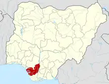 | |
This article is issued from Wikipedia. The text is licensed under Creative Commons - Attribution - Sharealike. Additional terms may apply for the media files.