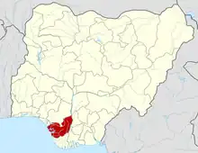
Uvwie
Ẹphrọn Effurun | |
|---|---|
 | |
| Nickname(s): Effa, Waff, Waffi, Waff town | |
 Uvwie | |
| Coordinates: 5°33′0″N 5°46′0″E / 5.55000°N 5.76667°E | |
| Country | |
| State | Delta State |
| Conurbation | Warri |
| Headquarters | Effurun |
| Government | |
| • Type | Local Government Chairman |
| • Chairman | Ramson Onoyake [1] |
| Area | |
| • Total | 35.68 sq mi (92.41 km2) |
| Population (2022)[2] | |
| • Total | 258,700 |
| • Density | 7,250.6/sq mi (2,799.48/km2) |
| Time zone | UTC+1 (WAT) |
Uvwie (/hu-we-ɛ/), is a principal Urban Local Government Area in Delta State. It lies along the Warri River and it is one of the twenty-four Urhobo Kingdoms. The entirety of the LGA is conurbated with the city of Warri, making it a greater part of Warri metropolitan area[3]
The term Uvwie primarily refers to the indigenous people of the geographic region, Uvwie also doubles as the name of the language and the Kingdom of Uvwie.[4]
More recently, Effurun which is the traditional and political headquarters of Uvwie Kingdom/Local Government Area is now used to refer to the city herself which is a twin city to the city of Warri[5]
The metropolitan area is known nationwide for its unique form of Pidgin, the Warri Pidgin[6]
History
The introduction of British colonialism in the late nineteenth century made Uvwie to become part of modern-day Nigeria which was created by the amalgamation of the Protectorates of Northern and Southern Nigeria in 1914. Since then foreign cultural pins like changes in the system of governance, dress codes, diets, Uvwie traditional architecture, economic activities and language have been inserted in the traditional culture. In response, the Uvwie traditional culture has strived to be assertive, on the one hand, and accepted to be an undercurrent, on the other hand.
Uvwie was a clan until 1954 when it became a Kingdom with the introduction of monarchy and Johnson Ejuvwiekoko Edjekohwo Eruohwo was crowned as Eruphwo II, the Ovie of Uvwie Kingdom on 1 December 1954. Political reforms have also made Uvwie a Local Government in the Delta State of Nigeria. Uvwie is being governed by the government of Delta State, the Uvwie Local Government, and the Uvwie Monarchy which is responsible for the traditional governance of the Uvwie Kingdom subject to the constitution of Nigeria and other laws.[7]
Geography
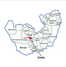
Uvwie is bounded by Okpe to the North, Udu to the South, Warri South to the West, Ughelli North to the East and Ughelli South to the South Eastern axis.
Until the 60s and 70s Uvwie and Warri was separated by arces of bushes and virgin lands there was an obvious boundary between both areas, during the exploration of Oil in the creeks, the former administrative capital and closest hinterland, Warri, attained a city status, due to the citing of various oil companies and firms the 30 km² town became congested. The western axis of Warri (Warri South West, Warri North and other parts of Warri South) had a swampy terrain so the expansion of the then booming city drifted towards its closest neighboring uplands, Uvwie, reason Uvwie plays host to the Warri Refinery and Petro Chemicals at Ekpan-Effurun and the former Warri Airport at Ugborikoko-Effurun and other Major institutes in the Metropolis
Residential areas
Some of Uvwie's more popular and well-known Neighborhoods are Effurun GRA (Government Reserved Area), Bendel Estate, Niger cat, Enerhen Junction, Uti Road, Ebrumede community, Okoribi, Ugbolokposo community, Okuatata/Ugbomro community, Iterigbi community, Alegbo Quarter, Alaka Quarter, Erovie Quarter, Jakpa Quarter, Aka Avenue, Enerhen community, NNPC housing complex, PTI, Ugboroke community, Ugborikoko community, FUPRE road, Refinery road, Effurun-Sapele road, Afieki Quarters, Udumuovwori Quarters. The main industrial area is located in Ekpan and the central town of Effurun.
Demography
People
Uvwie people (a subgroup of Urhobo) are the indigenous inhabitants of Uvwie, however due to her cosmopolitan status she has experienced a large influx of non-natives most especially the Ijaw, Isoko, Igbo and Itsekiri people amongst others
Religion
The city is predominantly Christian of Orthodox and Pentecostal denominations, however there's a sizeable populace that practices the Igbé religion with a few noticeable Muslims (from Northern Nigeria especially)
Language
Due to the multicultural and multiethnic background of the recent inhabitants of the city, the Warri dialect of the Nigerian Pidgin is commonly used as a means of communication, reason why the Uvwie language is gradually going extinct as it is not commonly spoken, even amongst natives [8]
Climate
Uvwie has an average temperature of 25 °C and has a number of rivers and streams flowing within its territory. The city witnesses two distinct seasons which are the dry and the rainy seasons with the total precipitation in the city put at an estimated 3170 mm of rainfall per annum [9]
Temperature throughout the year in the city is relatively constant, showing little variation throughout the course of the year. Average temperature are typically between 25 °C - 28 °C in the City [10]
Economics and infrastructure
Uvwie is the economic nerve center of Warri metropolitan area and Delta State at large.[11] Uvwie plays hosts to major revenue generating centers such as Gbagi Mall, Effurun. Delta Mall (ShopRite), Effurun. Warri Refinery and Petro Chemicals, Ekpan. Nigeria Gas Company, Ekpan. Water Resources, Ugborikoko. etc.
Uvwie houses most of the roads network linking the main town of Warri to other parts of the metropolis such as Osubi, Okuokoko in Okpe, Ovwian, Mofor in Udu, Otokutu etc.
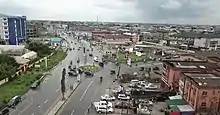
Enerhen Junction in Enerhen, Uvwie serves as a linkage between Uvwie, Warri and Udu
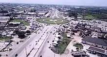
DSC roundabout is the gateway to the Delta Steel Company (DSC), Ovwian-Aladja at Udu, it also connects Okuokoko in Okpe, Uvwie and Otokutu near Udu.
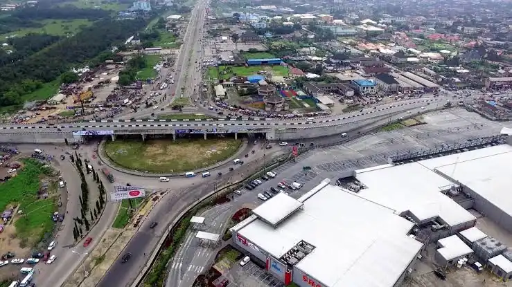 Effurun Roundabout in Effurun, Uvwie is the central spot in Uvwie and also a strategic location from other parts of Nigeria to the rest of the South-South, It is one of the routes that links Benin City via Benin-Sapele-Effurun to Port-Harcourt City via Effurun-Ughelli-Port Harcourt. It is the gateway into the main town of Warri in Warri South LGA, gateway to Warri Port, Ugbangwe-Warri via NPA express, gateway to Warri Refinery, Ekpan-Effurun (Uvwie).
See also
References
- ↑ Online, Tribune (September 30, 2022). "Uvwie council's health officers kick-off Environmental Day".
- ↑ "Uvwie (Local Government Area, Nigeria) - Population Statistics, Charts, Map and Location". citypopulation.de.
- ↑ "Redirect Notice". www.google.com. 15 August 2021. Retrieved 2022-12-11.
- ↑ "PTI 50th Anniversary: Ovie Of Uvwie, Others Honoured – Independent Newspaper Nigeria". independent.ng. Retrieved 2022-12-12.
- ↑ "Redirect Notice". www.google.com. 26 June 2022. Retrieved 2022-12-12.
- ↑ vanguard (2016-01-25). "Who will save Warri from its rot?". Vanguard News. Retrieved 2022-12-12.
- ↑ "Mindex Publishing". www.mindexpublishing.com. Retrieved 2022-12-14.
- ↑ Nwafor (2018-09-02). "Dabone makes case for survival of Uvwie dialect". Vanguard News. Retrieved 2022-12-12.
- ↑ "Uvwie Local Government Area". www.manpower.com.ng. Retrieved 2022-12-11.
- ↑ "ASSESSING THE SPATIAL DISTRIBUTION AND LOCATIONAL IMPACT OF PETROL SERVICE STATIONS ON UVWIE LGA, DELTA | ProjectClue". www.projectclue.com. Retrieved 2022-12-11.
- ↑ Jeremiah, Urowayino (December 30, 2017). "Once - troubled Uvwie kingdom metamorphosing into Delta's economic nerve centre". Vanguard News.
