Všestudy | |
|---|---|
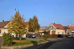 Centre of Všestudy | |
%252C_vlajka.svg.png.webp) Flag %252C_znak.jpg.webp) Coat of arms | |
 Všestudy Location in the Czech Republic | |
| Coordinates: 50°27′27″N 13°30′28″E / 50.45750°N 13.50778°E | |
| Country | |
| Region | Ústí nad Labem |
| District | Chomutov |
| First mentioned | 1325 |
| Area | |
| • Total | 5.11 km2 (1.97 sq mi) |
| Elevation | 317 m (1,040 ft) |
| Population (2023-01-01)[1] | |
| • Total | 180 |
| • Density | 35/km2 (91/sq mi) |
| Time zone | UTC+1 (CET) |
| • Summer (DST) | UTC+2 (CEST) |
| Postal code | 431 11 |
| Website | www |
Všestudy (German: Schößl) is a municipality and village in Chomutov District in the Ústí nad Labem Region of the Czech Republic. It has about 200 inhabitants.
Všestudy lies approximately 8 kilometres (5 mi) east of Chomutov, 44 km (27 mi) south-west of Ústí nad Labem, and 77 km (48 mi) north-west of Prague.
References
Wikimedia Commons has media related to Všestudy (Chomutov District).
This article is issued from Wikipedia. The text is licensed under Creative Commons - Attribution - Sharealike. Additional terms may apply for the media files.