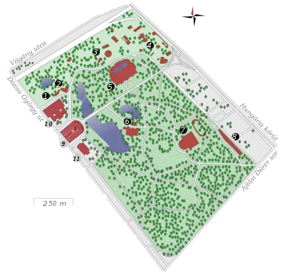
The City Park (Hungarian: Városliget; German: Stadtwäldchen) is a public park close to the centre of Budapest, Hungary. It is a 0.9-by-0.6-mile (1,400 by 970 m) rectangle, with an area of 302 acres (1.2 km2),[1][2] located in District XIV of Budapest, between Hungária körút, Ajtósi Dürer sor, Vágány utca and Dózsa György út. Its main entrance is at Heroes' Square (Hősök tere), one of Hungary's World Heritage sites.
Map
 |
|
Name
The area was formerly called Ökör-dűlő, meaning "Oxmeadow". The first mention of the name comes from 1241 in the archaic form, Ukurföld. In the 18th century, the area was called Ochsenried in German. Around 1800 the official name was changed to Batthyány-erdő (Batthyány Forest) after its tenants, the Batthyány family. The first trees and planned walkways were established in 1751 and after the public park was created in the first decades of the 19th century the present-day name, Városliget (and its German version, Stadtwäldchen, lit.: "little city forest") was accepted and it became one of the first public parks in the world.
History
The City Park was the main venue of the 1896 millennium celebrations of Hungary, by which time Andrássy Avenue, Millennium Underground and the Grand Boulevard had been built. Városliget (Budapest City Park) museum additions and renewal Liget Project[4]
Sports
The park hosted motorsport events in the 1950s.
Main sights
City Park includes the following sights:[5]
- Vajdahunyad Castle, opened in 1896
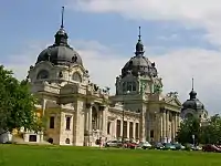
- Széchenyi thermal bath
- Budapest Zoo, including the Elephant House
- Municipal Circus, opened in 1891
- Gundel Restaurant, opened in 1894
- Budapest Circus Building[6][7][8]
- House of Music, Hungary opened January 2022[9][10]
- Museum of Ethnography, opened 23 May 2022[11]
See also
- People's Park (Népliget)
- Margaret Island (Margitsziget)
References
- ↑ "City Park, Budapest". aviewoncities.com. Archived from the original on 13 February 2019. Retrieved 17 January 2014.
- ↑ MapDevelopers.com (the area is displayed after clicking the inside of the selected polygon)
- ↑ "Map of Városliget". ligetbudapest.hu. Retrieved 2022-08-16.
- ↑ "About Liget Budapest projekt". ligetbudapest.hu. Retrieved 2022-08-16.
- ↑ "City Park". Budapest.com. Retrieved 27 March 2016.
- ↑ "Budapest Circus". Youtube. Archived from the original on 2021-12-13. Retrieved 4 October 2016.
- ↑ Youtube, Budapest Circus Lion Act
- ↑ "budapestagent.com, Budapest Circus". Archived from the original on 2018-09-13. Retrieved 2016-10-17.
- ↑ Inside the jaw-dropping House of Hungarian Music, retrieved 2022-08-16
- ↑ Novak, Benjamin (2022-02-02). "A Music Museum Opens in the Heart of Hungary's Culture Wars". The New York Times. ISSN 0362-4331. Retrieved 2022-08-16.
- ↑ "New Museum of Ethnography building in the City Park opens". ligetbudapest.hu. Retrieved 2022-08-16.
