| White Calf Mountain | |
|---|---|
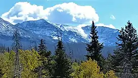 North aspect | |
| Highest point | |
| Elevation | 8,898 ft (2,712 m)[1] |
| Prominence | 973 ft (297 m)[1] |
| Coordinates | 48°38′40″N 113°24′27″W / 48.64444°N 113.40750°W[2] |
| Geography | |
 White Calf Mountain | |
| Parent range | Lewis Range |
| Topo map | USGS Saint Mary, MT |
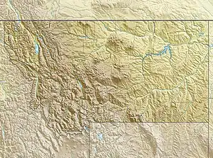
White Calf Mountain (8,898 feet (2,712 m)) is located in the Lewis Range, Glacier National Park in the U.S. state of Montana.[3] White Calf Mountain is south of Divide Mountain and just west of the Blackfeet Indian Reservation boundary.
See also
References
- 1 2 "White Calf Mountain, Montana". Peakbagger.com. Retrieved December 27, 2018.
- ↑ "White Calf Mountain". Geographic Names Information System. United States Geological Survey, United States Department of the Interior. Retrieved December 27, 2018.
- ↑ Saint Mary, MT (Map). TopoQwest (United States Geological Survey Maps). Retrieved December 27, 2018.
.jpg.webp)
East aspect

Divide Mountain (left), White Calf Mountain (center), Curly Bear Mountain (right) seen with Saint Mary Lake
This article is issued from Wikipedia. The text is licensed under Creative Commons - Attribution - Sharealike. Additional terms may apply for the media files.