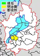
Map of Yasu District with Meiji period (1890) area in yellow.
Yasu (野洲郡, Yasu-gun) was a district located in Shiga Prefecture, Japan.
On October 1, 2004, the former town of Yasu absorbed the town of Chūzu, effectively turning Yasu District into Yasu City. Therefore, Yasu District was dissolved as a result of this merger.
As of 2003, the district had an estimated population of 49,155 and a density of 799.92 persons per km2. The total area was 61.45 km2.
Former Towns and villages
Transition
Light blue autonomies are Yasu District's town, deep blue autonomies are Yasu District's village, and gray autonomies are others.
| April 1, 1889 | 1889 - 1926 | 1927 - 1954 | 1955 - 1989 | 1990 - | Now | |
|---|---|---|---|---|---|---|
| Moriyama (守山) | February 1, 1904 Moriyama |
July 10, 1941 Moriyama |
January 15, 1955 Moriyama |
July 1, 1970 Moriyama City |
Moriyama | Moriyama |
| Kurita D Mononobe (物部) Village |
Kurita D Mononobe | |||||
| Ozu (小津) | Ozu | Ozu | ||||
| Tamatsu (玉津) | Tamatsu | Tamatsu | ||||
| Kawanishi (河西) | Kawanishi | Kawanishi | ||||
| Hayano (速野) | Hayano | Hayano | ||||
| Nakasu (中洲) | Nakasu | Nakasu | March 1, 1957 incorpotation into Moriyama | |||
| March 1, 1957 incorpotation into Chūzu |
Chūzu | October 1, 2004 Yasu City |
Yasu | |||
| Hyōzu (兵主) | Hyōzu | Hyōzu | April 1, 1955 Chūzu | |||
| Nakasato (中里) | Nakasato | Nakasato | ||||
| Yasu (野洲) | October 17, 1911 Yasu |
May 20, 1942 Yasu |
April 1, 1955 Yasu | |||
| Mikami (三上) | Mikami | |||||
| Giō (義王) | August 22, 1894 rename Giō (祇王) |
Giō | ||||
| Shinohara (篠原) | Shinohara | Shinohara | ||||
| Kitasato (北里) | Kitasato | Kitasato | March 3, 1955 incorpotation into Ōmihachiman (近江八幡) City |
Ōmihachiman | Ōmihachiman | |
This article is issued from Wikipedia. The text is licensed under Creative Commons - Attribution - Sharealike. Additional terms may apply for the media files.