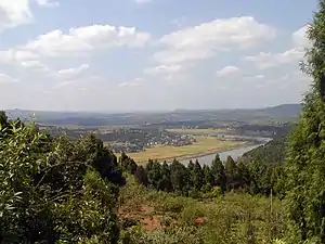
Zitong County
梓潼县 | |
|---|---|
 Zitong Panoramic 31°37′56″N 105°09′32″E / 31.63211769254885°N 105.1589985519027°E | |
.png.webp) Location of Zitong County (red) within Mianyang City (yellow) and Sichuan | |
| Coordinates: 31°38′35″N 105°10′16″E / 31.643°N 105.171°E | |
| Country | People's Republic of China |
| Province | Sichuan |
| Prefecture-level city | Mianyang |
| Area | |
| • Total | 1,438 km2 (555 sq mi) |
| Population (2018)[1] | |
| • Total | 309,000 |
| • Density | 210/km2 (560/sq mi) |
| Time zone | UTC+8 (China Standard) |
Zitong County (Chinese: 梓潼县; pinyin: Zǐtóng Xiàn) is a county in the northeast of Sichuan Province, China. It is under the administration of the prefecture-level city of Mianyang.
It has an area of 1,438 km2 (555 sq mi), and a population of 380,000 in 2002. Its seat is 172 km (107 mi) from Chengdu, and 49 km (30 mi) from Mianyang. It was made a county as early as B.C. 285, in Qin Dynasty.
Famous people include: Sima Xiangru, Pu Fuzhou, Hai Deng, Li Youxing.
Historical sites
Zitong has three historical sites listed in the official list of Chinese national historic sites.:[2]
- Qiqushan temple (Qiqushan damiao, 七曲山大庙)
- Liye tower (Liye que, 李业阙)
- Wolongshan temple (Wolong shan Qianfo yan shiku, 卧龙山千佛岩石窟)
Aftermath of the 2008 Earthquake
Zitong, like neighbouring counties, was located near the epicentre of the 2008 Sichuan earthquake.[3] Infrastructures in Zitong was partly destroyed, and drinking water was not available.
Also the Qiqushan Temple, who is since 1996 on the official list of Chinese national historical sites was partly destroyed by the earthquake.[4]
Climate
| Climate data for Zitong (1991–2020 normals) | |||||||||||||
|---|---|---|---|---|---|---|---|---|---|---|---|---|---|
| Month | Jan | Feb | Mar | Apr | May | Jun | Jul | Aug | Sep | Oct | Nov | Dec | Year |
| Mean daily maximum °C (°F) | 9.8 (49.6) |
12.6 (54.7) |
17.5 (63.5) |
23.4 (74.1) |
27.4 (81.3) |
29.6 (85.3) |
31.3 (88.3) |
31.1 (88.0) |
26.2 (79.2) |
21.2 (70.2) |
16.4 (61.5) |
11.0 (51.8) |
21.5 (70.6) |
| Daily mean °C (°F) | 5.6 (42.1) |
8.2 (46.8) |
12.5 (54.5) |
17.7 (63.9) |
21.7 (71.1) |
24.5 (76.1) |
26.3 (79.3) |
25.9 (78.6) |
21.8 (71.2) |
17.1 (62.8) |
12.2 (54.0) |
6.9 (44.4) |
16.7 (62.1) |
| Mean daily minimum °C (°F) | 2.4 (36.3) |
5.0 (41.0) |
8.7 (47.7) |
13.2 (55.8) |
17.3 (63.1) |
20.7 (69.3) |
22.7 (72.9) |
22.3 (72.1) |
18.8 (65.8) |
14.4 (57.9) |
9.2 (48.6) |
4.0 (39.2) |
13.2 (55.8) |
| Average precipitation mm (inches) | 6.6 (0.26) |
8.9 (0.35) |
19.2 (0.76) |
41.1 (1.62) |
81.1 (3.19) |
118.1 (4.65) |
224.1 (8.82) |
151.3 (5.96) |
131.6 (5.18) |
44.1 (1.74) |
12.8 (0.50) |
4.8 (0.19) |
843.7 (33.22) |
| Average precipitation days (≥ 0.1 mm) | 5.6 | 5.5 | 8.1 | 10.2 | 12.2 | 13.4 | 14.5 | 12.7 | 13.6 | 12.2 | 6.1 | 4.2 | 118.3 |
| Average snowy days | 1.6 | 0.6 | 0.1 | 0 | 0 | 0 | 0 | 0 | 0 | 0 | 0 | 0.5 | 2.8 |
| Average relative humidity (%) | 73 | 71 | 68 | 68 | 66 | 74 | 79 | 79 | 80 | 79 | 77 | 74 | 74 |
| Mean monthly sunshine hours | 62.8 | 61.0 | 93.7 | 123.0 | 131.3 | 119.2 | 134.6 | 146.0 | 81.1 | 68.6 | 67.6 | 62.2 | 1,151.1 |
| Percent possible sunshine | 20 | 19 | 25 | 31 | 31 | 28 | 31 | 36 | 22 | 20 | 22 | 20 | 25 |
| Source: China Meteorological Administration[5][6] | |||||||||||||
References
- ↑ "Zĭtóng Xiàn (County, China) - Population Statistics, Charts, Map and Location".
- ↑ "Denkmäler der Volksrepublik China (Sichuan)", German Wikipedia
- ↑ "China Earthquake Events, May 2008" Archived July 22, 2011, at the Wayback Machine, GLOBAL ATLAS on Crisis Areas by the European Commission
- ↑ "Earthquake partly destroyed the Qiqushan-Temple" Archived November 3, 2008, at the Wayback Machine
- ↑ 中国气象数据网 – WeatherBk Data (in Simplified Chinese). China Meteorological Administration. Retrieved 17 September 2023.
- ↑ 中国气象数据网 (in Simplified Chinese). China Meteorological Administration. Retrieved 17 September 2023.