Černěves | |
|---|---|
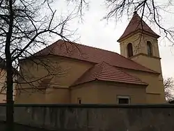 Church of Saint Procopius | |
 Flag  Coat of arms | |
 Černěves Location in the Czech Republic | |
| Coordinates: 50°27′16″N 14°14′36″E / 50.45444°N 14.24333°E | |
| Country | |
| Region | Ústí nad Labem |
| District | Litoměřice |
| First mentioned | 1233 |
| Area | |
| • Total | 4.56 km2 (1.76 sq mi) |
| Elevation | 153 m (502 ft) |
| Population (2023-01-01)[1] | |
| • Total | 231 |
| • Density | 51/km2 (130/sq mi) |
| Time zone | UTC+1 (CET) |
| • Summer (DST) | UTC+2 (CEST) |
| Postal code | 413 01 |
| Website | www |
Černěves is a municipality and village in Litoměřice District in the Ústí nad Labem Region of the Czech Republic. It has about 200 inhabitants.
Černěves lies approximately 13 kilometres (8 mi) south-east of Litoměřice, 27 km (17 mi) south-east of Ústí nad Labem, and 43 km (27 mi) north of Prague. It is about 3 km from Roudnice nad Labem.
References
External links
Wikimedia Commons has media related to Černěves (Litoměřice District).
This article is issued from Wikipedia. The text is licensed under Creative Commons - Attribution - Sharealike. Additional terms may apply for the media files.