Hrobce | |
|---|---|
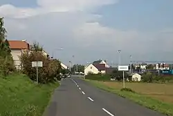 View from the south | |
 Flag  Coat of arms | |
 Hrobce Location in the Czech Republic | |
| Coordinates: 50°27′45″N 14°13′51″E / 50.46250°N 14.23083°E | |
| Country | |
| Region | Ústí nad Labem |
| District | Litoměřice |
| First mentioned | 1115 |
| Area | |
| • Total | 7.38 km2 (2.85 sq mi) |
| Elevation | 153 m (502 ft) |
| Population (2023-01-01)[1] | |
| • Total | 715 |
| • Density | 97/km2 (250/sq mi) |
| Time zone | UTC+1 (CET) |
| • Summer (DST) | UTC+2 (CEST) |
| Postal codes | 411 83, 412 01 |
| Website | hrobce |
Hrobce (Czech pronunciation: [ˈɦroptsɛ]) is a municipality and village in Litoměřice District in the Ústí nad Labem Region of the Czech Republic. It has about 700 inhabitants.
Hrobce lies approximately 12 kilometres (7 mi) south-east of Litoměřice, 26 km (16 mi) south-east of Ústí nad Labem, and 44 km (27 mi) north of Prague.
Administrative parts
The village of Rohatce is an administrative part of Hrobce.
References
Wikimedia Commons has media related to Hrobce.
This article is issued from Wikipedia. The text is licensed under Creative Commons - Attribution - Sharealike. Additional terms may apply for the media files.