Klapý | |
|---|---|
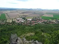
 Klapý seen from Hazmburk | |
 Flag  Coat of arms | |
 Klapý Location in the Czech Republic | |
| Coordinates: 50°25′53″N 14°0′24″E / 50.43139°N 14.00667°E | |
| Country | |
| Region | Ústí nad Labem |
| District | Litoměřice |
| First mentioned | 1197 |
| Area | |
| • Total | 8.95 km2 (3.46 sq mi) |
| Elevation | 239 m (784 ft) |
| Population (2023-01-01)[1] | |
| • Total | 483 |
| • Density | 54/km2 (140/sq mi) |
| Time zone | UTC+1 (CET) |
| • Summer (DST) | UTC+2 (CEST) |
| Postal code | 411 16 |
| Website | www |
Klapý is a municipality and village in Litoměřice District in the Ústí nad Labem Region of the Czech Republic. It has about 500 inhabitants.
Geography

Hazmburk Castle
Klapý is located about 14 kilometres (9 mi) southwest of Litoměřice and 26 km (16 mi) south of Ústí nad Labem. It lies in a flat agricultural landscape of the Lower Eger Table from which the Hazmburk hill rises in the eastern part of the municipality. It is the highest point of Klapý with an altitude of 418 metres (1,371 ft).
Sights
There is a ruin of a medieval castle on the Hazmburk hill.
Notable people
- Lubor J. Zink (1920–2003), Czech-Canadian writer
References
Wikimedia Commons has media related to Klapý.
This article is issued from Wikipedia. The text is licensed under Creative Commons - Attribution - Sharealike. Additional terms may apply for the media files.